
A month ago I received an email from a race director who wanted her marathon course certified. I pointed her to the RRTC web page and urged her to do it herself. I also pointed her to the online list of Ohio measurers who might be willing to measure it for her. I did not receive a reply.

Yesterday she called, and we began playing telephone tag. I am still uncertain what she wants, as it’s her turn to call and it’s now the weekend. I think she will want me to measure the course. The course is 60 miles from me, and about a 1:20 drive from home.

Initially I had little enthusiasm for measuring a marathon course, but then I looked up the race online and found that it had been plotted on USATF's "America's Running Routes." The course came out several hundred meters long. I have confidence in that program. What got me more enthusiastic was the fact that over 20 miles of the course is on a rails-to-trails bikeway. I like these, as there are no significant hills. The first mile is in Town A, 4½ miles on the bike path, then 3 miles plus ¼ mile to finish in Town B, and the remainder on the bike path to the TA at town C.

Here’s my plan. See the diagram below:


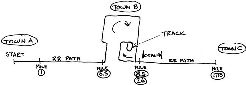
I’ll drive to town B and lay out a cal course on a dead-straight piece of the bikeway. Then I’ll calibrate and measure from Mile 8.5 to the TA at Mile 17.25, and back to Mile 8.5. If I have time and energy left I’ll measure to the finish. Then go home.

Next day I’ll go again to Town B, calibrate, and measure from Mile 8.5 to the start. Now I will know how long the course is. Hopefully it will be a bit oversize, and I will be able to use the existing desired start point. I’ll ride from start to Mile 8.5, laying down splits as I go, recalibrate, and go home. I’ll check my numbers and determine how much I have to shorten the course by moving the TA at Town C.

Third day I’ll go to Town B again, and measure from Mile 8.5 to the adjusted TA, and back to Mile 8.5, laying out splits enroute. When I get back to Mile 8.5 I will have two measurements of the entire course.

I could save a day by assuming that the course is actually a bit too long, but this isn’t a good option, as if I am wrong I’ll have laid out a pile of unusable splits. I believe the start and finish will be pretty well unadjustable, leaving the TA as the only adjustment option

Does anybody see holes in this reasoning? Is there a better way? I like to minimize my riding to save energy. Also, now that the RD has wasted a month making up her mind it is getting toward cold weather, and the days are shorter.

Of course, all of the above assumes that she will actually call back and agree to my terms.
Original Post

Replies sorted oldest to newest

Pete,

How about going from the start to 8.5 and laying out these mile marks. When you reach 8.5 find the distance to the finish then ride from 8.5 back to the start. After computing the numbers you will then know what distance is needed to the turn for the next day's ride.

Next days ride you could set your mile marks as you ride to the turn.

Gene
Pete,

Assuming the TA is the only marker where the course can be adjusted, then the measurement could be completed in two days. On day one, lay out your calibration course as you had specified, and calibrate. Measure from Mile 8.5/26 marker to the fixed start. Then, ride from the start back to Mile 8.5/26 marker and lay the splits along the way back.

If there's time on the first day, measure the distance between the Mile 8.5/26 marker to the finish on the track. Then, ride from the finish back to Mile 8.5/26 marker and lay the splits along the way back.

At the end of the first day, you'll know the distance from the start to the Mile 8.5/26 marker as well as the distance from the finish to the Mile 8.5/26 marker. Now, you can calculate the remaining distance to make up the marathon as well as the split locations. The turn-around will be located at one-half of that remaining distance.

On day two, calibrate, and measure from the Mile 8.5/26 marker toward the TA and locate the new TA. Then, ride from the TA back toward the Mile 8.5/26 marker and lay out the splits along the way back.

Let me know what you think. -- Justin
Justin, you and Gene have both proposed what would be a good way to do it. What scares me off is that I am not yet certain that there is enough room in the TA leg to fit the course. If I try to measure it on day 2, and run out of bike path before I get to the TA, I will have made a bunch of useless marks. On the other hand, even if it does come up short I will have a full course measurement.

Seems like it may be worth taking a chance.

I'll know more when (if?) the RD gets back to me.
quote:
In order for that to work I'd have to have enough room at the TA end. I don't know yet that I have it.


I think you don't have enough information. I would also think it a good idea to find out who designed the existing course, for that may be different than the RD or head of the group that wants to put the event on.

Adjusting the TA sounds like the simplest solution for a large course adjustment. Going over possible course adjustments on site can save you a lot of time later. This is especially true for a long course being organized by less experienced RD's, which is what it sounds like in this case.

Before tackling the course I think I would:
1) Find out what is adjustable.
2) Find out why the existing locations of the start and finish were selected.
3) Determine the number of runners the event is being designed for.

I would schedule your first visit to meet the event director and their course manager.
On that day, preferably with their help:
a) Lay out the cal course
b) Visit all the key points by road
c) Determine and mark the optimal start,
finish and proposed TA.
d) Take GPS readings of each point, along
with the points where the course turns
from the rail bed to the town roads.
e) Check the proposed route through town B,
determining what part of which roads will
be used. If on any part if only part of a
road is used.
f) Mark known fixed points, (where length
adjustment will not be made) and record
measurements to known fixed points.

I would also discuss with the event directors if the start has enough road width in the first couple of miles and the space available behind the line to assemble runners. .. Again for the finish layout.

It is better that they have thought it though before you start to ride.

Make sure they have provisional permission for the route through town 'B' before you measure that part of the course. You don't want the police changing the course after the measurement.

Armed with this data, I would either return home, or retire to a building with a computer and mapping software.

I would check the length with a couple of different mapping programs and get the RD to sign off on the preliminary route and method of adjusting the course length.

GoogleEarth is useful for approximation, especially when dealing with trails that are not on the road maps.

Verify there is enough distance. Agree with RD on the exact Start, Finish, the route to be taken and the where you will adjust the course length.

Only then would I set out do ride. I would plan to do this on a different day, some time later, after all has been agreed.

I would try be organized, have pre-printed worksheets, arrive early and have on site assistance from a local.

If you know all of the above, you can do the first ride and put down splits at the same time.

(Working on the assumption that only the total length is being certified and not the splits..)

Start by calibrating the bike.

Find out Start, Finish or TA will be adjusted. If Finish, just do normal measurement, Start to Finish.
If Start, do same but ride Finish to Start.

If it is, as I suspect the TA that they want adjustments at, then:

Measure location of start pin from fixed points.

Ride from the start to the TA, laying out splits as you go, then from the TA to the finish but without laying down splits.

Then figure out the gross course adjustment. Ride back from the Finish to TA putting down splits as you go.

Now the splits are all in the correct locations even though you have not yet adjusted the TA.

You could make the gross course adjust at the TA and measure it's new location from fixed points, or just continue to Start and make both gross and fine adjustments to the TA after riding.

Have car pick you up, take you to lunch, and then return you to the start for full ride, or return to finish and do the next ride in reverse.

Re-cal the bike and run the numbers.

Make final course adjustment, if necessary, measure pin's distance from fixed points and go home.

This plan did not split the riding up across different days, One day was all prep, the second all ride. The advantage is having all the uncertainty out of the picture, so the second day should be smother and with less to worry and think about and therefore less prone to error.

Even better, have a local on a second bike ride with you. Just charge the cost of the second Jones counter to the event.
Yesterday I made contact with the RD by phone. She had mislaid my email of a month ago. I re-sent it and gave her a price for the job.

I’ve since researched the event and I think there’s a strong probability that the measurement won’t happen. Last year’s event had only 51 individual runners and 130 total, counting the relay people (event has 3.1, 10, and 13 mile legs). I don’t think the event can afford my fee. But we will see. I hope I’ll get the job, as the ride looks pleasant. Of course, if it happens in December or January the pleasure may be diluted by the cold weather.

The event is the Earth Day Marathon, starting in Mt Vernon, Ohio.

The web page for the event is: http://athletics.kenyon.edu/PreBuilt/EDC.pdf

The route as plotted on America’s Running Routes is found at: http://www.usatf.org/routes/view.asp?rID=122678

If it happens I expect to travel to Mt Vernon to meet the RD.
Then I will have her locate the exact start line.
Then I’ll drive to Gambier and lay out the cal course.
Then (time permitting) I’ll measure from Mile 8.5 to the start, and back again, laying out splits on the return ride.

Next day I’ll ride 8.5 to the TA and back again, and with luck there will be room on the bike path to fit the course. I’ll lay out the splits on the return ride if the course fits. If I run out of room I’ll need a third day to add a block or two in Gambier to get added distance.

All in all I’m guessing that three days will do the job.

I believe many of Jim’s suggestions may be overkill, as some of them are the responsibility of the RD and not the measurer. Also, the course has already been run once, and its route is known. One suggestion is essential, and that is to agree beforehand where adjustments can be made if distance needs to be added. Nothing is more frustrating than to have indecision at this point.

Google Earth isn’t much help in the area, as the photos aren’t high-definition.

A second rider on an out-back course is just excess baggage, as it will save me no riding.

One thing I regret is that if they want the course measured they cannot obtain a Jones Counter to do it themselves. Even I do not own one – I am using my chain-drive counter these days. There is always the electronic option, but I don’t think they will be up to it.

If anyone out there is interested in doing the job for nothing, let me know and I will put you in touch with the RD, and no hard feelings.
Pete, it looks like there's a small amount of "wiggle room" at the start as well. You might check that out when determining your course of action.

I can see your desire to measure this course - the rail trail looks really scenic. This one's topography appears forgiving, but one of my tougher rides was on the Mickelson Trail in the South Dakota Black Hills. It was surfaced in small crushed stone which made traction iffy in parts and the final six miles from Hill City to Crazy Horse was all uphill, at whatever the maximum grade permitted for a train.
Pete,

First, I just measured your trail from the inline with Meadow Ln. on the trail to the NE end of the Kokosing Gap Trail, using ArcExplorer. ArcExplorer is a free viewer from ESRI, makers of high-end mapping software. You may download ArcExplorer free from their Website. HOWEVER, I have not gotten it to work on my personal computer or laptop, due to video driver issues. Have tried to resolve them, to no avail. No guarantees on your computers.

That said, the distance from Meadow Ln. to the NE end of the trail is 8.842 miles, give or take a couple hundred feet.

Your sketch shows runners doing almost a complete lap on the track. The track is .25 mile, if it is a regulation track. Sketch also shows Mile 26 out on the trail. Now, in my book, the Marathon is 26.21876 miles. So, the sketch has extra length in it.

BUT, given that I ASSUME that it is 8.3 miles from the Start to Meadow Ln & Trail, AND, if Mile 26 is actually closer to the track than the sketch shows, you SHOULD have ample room on the trail for your spur.

So, I must disagree that you don't have use for a co-rider. My method:

Take co-rider (and two cars) to Cal Course and lay it out. Calibrate.

Drive one car (with both riders) to the Start. Lay out your mile markers as you ride to Mile 8.5 or Mile 9 (point is to get beyond the trail junction). Should be good as gold.

Both riders ride to Finish. From Finish, ride backwards (mark Mile 26 when you get there) to your stopping point (Mile 8.5 or Mile 9, whichever you chose). You now know (after doing some math) exactly how long your spur to the northeast needs to be. Ride to the turnaround and back, marking your miles from Mile 9 thru Mile 25. Finished! (As long as your two rides are within tolerance, and you have been marking the "longer" measurements.

If I did it myself, with no co-rider, I would calibrate, drive to Start, ride Start to Mile 9, then find distance from Mile 9 location to the Finish, so I could calculate how long my spur needs to be. I would mark Mile 26 while there. Now, I'd ride back to Start to finish the measurement of the first 9 miles. I would adjust the Mile 9 point if an adjustment is necessary.

On my second day, I would ride and mark the spur, as I do believe there is plenty of room, especially if runners make an entire lap on the track.

I have started doing my Marathon courses with a co-rider, and that is much better than alone. Although, with the trail, you don't have to worry much about traffic, except through that short stretch in town.

Good luck. Wish my Marathon courses were that flat!
I’ve found that riding with another measurer usually doesn’t save me time. The reason is that on the first ride of most courses it takes one complete course ride just to find what’s there, and adjust it. Then a second ride is needed. It doesn’t help me any to have two rides of the initial exploration, as I must do another one anyway.

Of course, it’s generally more fun to have company.

In 1999 I measured the course of the inaugural Flying Pig Marathon, in Cincinnati, Ohio. I was fortunate to have Mike Wickiser available as a second rider. Although he lives near Cleveland, he was visiting his daughter in college near Cincinnati. We rode the course together, stopping every so often at reference landmarks. This gave us two complete measurements of the unadjusted course.

At that point Mike went home and I finished the job myself on subsequent visits to Cincinnati. With the landmarks accurately known, I worked out final locations for start and finish.

The splits were easy to locate, as each one was no more than a mile or two from an accurate, certifiable reference point. All in all, with changes of RD mind involved, it took me five trips to Cincinnati to get the job done. I wasn’t happy about this.

On the Earth Day Marathon, with everything being out-back, I figure the job will involve less than 30 miles of riding. Each “out” segment will get its second measurement on the “back” ride. Doing it with two people would save me, at best, about five miles of riding.

Disadvantages are:

1) I don’t have a local friend to help. I could find one I suppose. There are one or two local people who could help.
2) When measuring with others, there is always extra time taken with meeting up and having to pre-plan. When I measure by myself I can wake up and see what kind of a day it is, and measure on my own schedule. With others involved I have less flexibility.
3) When riding in company I tend to make more mistakes when I am the lead rider. Sometimes an interesting conversation gets me sidetracked.
4) This is not a disadvantage, but the biggest help of a second person is in laying out the calibration course. I plan to do this solo. I hate to use inexperienced people at the other end of the tape.

Present status of the job is that I dropped the price a bit because the race is so small. The RD says she will be seeking to get funding from her Board. Maybe it will happen, maybe not.

If she can’t get funding I have offered to coach her, or her surrogate, in doing it themselves. I hope I don’t have to do this, as without a Jones counter presently available I’ll have to first educate her on setting up the electronic option, and then going on to actual measurement. I suspect this will be too tough for a newbie, especially as it’s a full marathon course.
Last edited by peteriegel
Sorry your co-rider experiences have not worked well. I just measured the Colfax Marathon last weekend, and it was great. I was the lead bike, so I went to each split point (miles, and 5K multiples). I would mark the point, roll forward 5', set a GPS waypoint, and record the location description. By then, Cliff arrived, and he recorded his click count. We compared, to make sure we were accurate, then I left. He stayed and took the photo of the point and wrote his count down. Repeated along the entire course.

We finished the entire course, including calibration rides and driving to an from the course, in 7.5 hours. It would have taken me that long for one ride, then I would have had to go back for my second ride. I will use a co-rider for every Marathon course, and most Half-Marathon courses. (This was a loop course, so we were basically back at the Start when we finished.)

Good luck with the measurement. It is a big help to have the mapping tools available now, so you can work through most of the issues before going to the course.

Oh, I noticed "an interesting conversation...". Isn't the prescribed proceedure to have each rider ride separately, so each can take their own "shortest possible route"? Big Grin
The beauty of co-riders. If we are within clicks of each other, we are good. And, our adjustment is in the last mile, if needed. Lots of pre-ride measurements with different software. Eliminate all foreseeable bugs before the ride.

Having done 70 courses in the last two years, I am gaining confidence in my processes. On shorter courses, I do a preliminary mark on my first ride, which is when I do my elevation profile, then do my nails on my second ride.
Just got the word. The measurement is ON.

I'll be meeting with the RD at 9:30 AM today at her office in Gambier. She will show me the finish. Then we drive to Mt Vernon, where she will show me the start. I'll ask some questions.

Then she's done and I am on my own. A solo layout of a cal course (east of the Gambier junction) will be first, with the west end being my main reference point for the measurements. Then measure to the finish. Then measure the in-town Gambier route to another reference point on the path just west of Gambier.

Then, if time and energy permits, a ride to the start and back.

Pavement is dry and no rain predicted today.
SOLO CALIBRATION COURSE LAYOUT

This is done by putting a series of nails in the pavement, leaving the heads protruding a bit. You hook your tape over the first one and measure to the second and record the measurement. Then you walk back, unhook the tape from the nail, and drag it far enough to hook it on the second nail. You hook it on and measure to the third nail. Proceed until you have enough length for a calibration course. When you are done you add up all the segments. Be sure you account for the offset between the center of the hook-on nail and the zero point of the tape. The offset will apply to each segment.

The first time I did this I went through the procedure from one end to the other. Then I did it in reverse order. There was a lot of walking back and forth.

It struck me that if I simply read the tape twice, this would count as two measurements. However, I have had enough misreadings to not trust this. It’s easy to get the same wrong reading twice.

Yesterday I tried a different approach. I have a tape that is 100 feet on one edge and 30 meters on the other. I put nails in just shy of 100 feet with a limp tape. Then I stretched it and read the metric value. Then I read the feet/inches. I believe this qualifies as two measurements.

I recorded the tare (amount to be deducted) as ¼ inch and also 5 mm.

Below is how the data looked.

Last edited by peteriegel
I’VE BEEN WORKING ON THE RAILROAD…..

The weather last weekend was tolerable, with iffy predictions for snow or rain, but I did get a chance to go to Gambier and measure the marathon course. I met with the RD, got some questions answered, and laid out the cal course. There was a great spot for it, right next to the locomotive on the Kokosing Gap Trail, where the course begins its final out-back. It’s shown below:


Calibration course begins at the lamp post by the bike rack and goes straight past the engine.

Friday I measured from the locomotive eastward to the start, and back again. This stretch includes the loop through Gambier, which has one big hill. It was a toughie, especially when I had a couple of off-course moments and had to retrace and ride the hill again. So I got four trips up the hill.

I would have gone again Saturday to finish the job, but the Ohio State – Michigan game was the diversion of choice. Go Bucks.

Sunday was an easy out-back from the locomotive to the east end of the course in Danville, and I was pleased to see that there were a couple hundred meters to spare. I’d been painting splits as I went east, and would have been grieved to have to change them. Enroute I passed through a short tunnel:


I was happy to be done with the riding before the snows came. Once these bike paths get snow-covered, they generally don’t get plowed, and I hate to have half-finished work sitting around.

Couldn’t resist a final tourist shot:


Now for the course map and the paperwork. I can't remember a marathon course that was more fun to measure.
Pete,

Looks like you had a good measurement! Glad things worked for you.

See, with planning and luck, you can set out your marks on the first ride! Wink

Please send me your map when it is done, along with the race date. You can be the first Ohio course listed on my RaceMeasure.com site!

Way to go Buckeyes! (I partially grew up in Dublin, and ushered OSU games as a Boy Scout.)

I'll send the cert and map when it's done. Probably will be a week or two. Pete
Last edited by peteriegel
Pete, re: your metric/Imperial 2 measurement technique for cal courses. I guess this qualifies for 2 measurements as much as 2 done in the same units would, but I'm always leary about mixing the two units (and I'm sure Bob Baumel is positively apoplectic in reading this, hence his lack of reply - he's probably sitting paralyzed in shock at his comuter).

I work solely in metric untis (since the mile is officially defined that way, it's not hard to figure out, but quite another story going the opposite direction). I've measured a couple times w/ guys who work in Imperial, and I always feel like an American astronaut working w/ a Russian counterpart on the Int'l Space Station - we're not really talking the same language. It's like apples and oranges. It really gets to be a pain when doing a marathon or half marathon, and they're trying to figure out the 385 yards byond 26 miles, while I've got my 42,195m easily calculated.
I've found that taking the same reading twice on the same scale is liable to produce a second reading error if the first one is read wrong. I originally thought I would hook two tapes to the nails, and read them one after the other, but found the one I used. It was the first time I'd used the feet/inches scale - I much prefer decimal feet.

I also have to take more care when reading a metric tape. I've found that even people who live in metric-using countries sometimes have a hard time getting the decimal point in the right place.

What I like about using feet is that the whole foot is right in front of my eyes, and I easily see the fractional foot.

But I do use meters in all my race calculations except for mile splits.
I agree - I am very careful when taping metrically to make sure I'm reading the correct decimal place. But once that's done, it's a lot easier working metrically for the actual on-course measurements. Hugh Jones was the guy who convinced me to think of it as putting marks every 1609.344m rather than every mile. Since the majority of courses I measure are metric (and that includes half & full marathons - I absolutely HATE working in miles and yards, or worse, fractions of a mile for those distances) it's way easier. Even 3- and 5-milers are easier for me if thought of as 4828.032m or 8046.72m.
Maybe I'm dense, but what is the difference between putting marks every mile, then one at 3.10686 miles, and putting marks at multiples of 1609.344m and then one at 5K? Using decimals in each situation. Besides, ulitimately it comes out as (18425 for me) clicks on a Jones, so why does it matter if you get there with metric math or Imperial math?

I guess I don't see why either one is "better" or eaaier than the other. TomAtoe, tomaahto.
Unless you've got a decimal foot tape, it's very hard to locate 3.10686 miles, whereas 1609.344 is easily locatable on a metric tape.

But the real reason should be that the mile is defined by an exact metric distance, but the converse is not true - Imperial equivalents are just approximations - maybe sufficiently accurate for our purposes, but why introduce another possible source of error that's not needed? For instance, if I convert 5km I get 3.106856 miles. But then if I convert that figure back, I get 5.0000001 km, indicating there's some imprecision creeping in here.
Last edited by jimgerweck
Jim,

You touched on my point - why worry about a 7th-decimal point lack of precision when we make every course longer by a 3rd-decimal point lack of precision?

And, we use Jones counts, not tape measures when we do our courses.

When doing a calibration course, we strive to be absolutely accurate. That can be done with Imperial or metric. If the operator can't read a tape accurately, it that the fault of the methodology? No, it is the fault of the user. To make it crystal clear, if I shoot 95 for a round of golf while using Tiger's clubs, does that mean he needs new clubs, or just that I am incompetent in the use of those clubs? It is the user, not the tool, that determines accuracy in our field.

Have a great Thanksgiving, all.
MILEPOST MILES VS CALIBRATED BIKE

I’m all done with measuring the Earth Day Marathon. While laying out the splits there was nothing on the Kokosing Gap Trail to use as split landmarks, so I used the existing permanent trail mileposts as reference points. Enroute I got measurement data between most of the posts. My calibration change was only 2.5 counts/km on the first day and 1.3 on the second day.

I don’t know what method was used to lay out the posts, but it looks like they got them right.

Below you will see how it came out. Milepost 8 seems off, but it was located at the edge of a cross-road. Perhaps they didn’t want to put the post in the road, so they put it as close as they could get it.

"Error" calculation assumes that the mileposts are in exactly the right place.

It was interesting to read through this topic, because I was just contacted by a RD who wants a marathon measured that's a full 3 hours away from me. It's a small charity-driven race, so I doubt the RD will follow-through due to the cost.

I strugged with the pricing a bit because of the distance from me. I'm also torn because I feel compelled to help, but I don't really want to travel that far. In the end I offered to do it for about half of what could be considered a standard fee, but it's still a significant chunk of money for a small race in a small town.

As I put together a proposal, I couldn't help thinking that there's no way the RD would appreciate the amount of work involved in the measurement, and she would likely dismiss my offer as exorbitant.
E.,

I think you sell yourself short when you feel compelled to lower your price due to the race's circumstances, for a number of reasons.

First, the race may be small the first year or two, but then grow to a large, regional, then national, event. They may end up making much more for their charity in the coming years than they think , if they produce and market their race well. There are expenses involved in setting up a quality event.

Second, yes, there is alot of work involved, and why should you be the person to donate your time (or donate half of your fee), just because you have something they need? Sponsors don't get involved with an event if there is no compelling reason, be it publicity, a connection with the cause, or they need the tax benefits. If you are not in a position to absorb the "donation", don't make the donation in the form of a reduced fee.

Third, if they can't afford the certification, and you don't want to donate the certification, they can get pretty darn close to the correct distance this year, using MapMyRun.com. Then, if the event grows, they can have it certified next year. Just because I want a BMW, does not mean that a dealer must sell me one at a price I can afford. I can buy a cheaper car, and it will do until I can afford what I want.

Plus, certifications can pay for themselves in the form of additional entrants. If they have a $75 entry fee, it will only take 24 extra runners to pay for the certification (disregarding the cost of t-shirts, etc.). For that reason, I don't think a full-fee certification is out of line. You could discount the Half fee, if it follows the same course, and you can measure and mark it at the same time as the full marathon measurement ride.

If you can't go back and get your full fee, or, if she still feels that your discounted fee is too much (after explaining the benefits of certification AND THEN MARKETING the certification of her race), you could help her with her course on MapMyRun.com this year, then she can get it certified next year. She will appreciate your help in saving money the initial year, then will likely want you to certify it after she sees if she has enough participation to continue the event.

Besides, the fee is good for 10 years, so on a per-year basis, it is a small price to pay for accuracy in her course.

Just my thoughts.
I don't know your charge, but Duane is right on! I feel that a fair price should not be lowered. The question is what is fair?

Your travel time is important as well as the type of course you are measuring. If it's an out and back then you could charge less. I generally charge about $50 per mile plus $100 for the paper work. In your case I would build in some charge for travel. Then another thing to consider is: do you have to design the course? If that's the case then that would involve some extra charge.

They could always do it themselves by following the guidelines, but if they choose to ask for an expert then present your charges and don't worry about their answer.
The first question any potential marathon entrant is going to ask is, "Can I qualify for Boston there?" And the answer is definitely "No" if it's not certified. So the race will quickly find that certification is the most cost-effective expense it's going to have, in terms of attracting entrants - much more than pretty T-shirts, on-course hula dancers, or a post-race feed and entertainment to rival the Roman circus maximus.
Great comments...thanks everyone. I wish I would have posted here before I sent the proposal. From here on out, I'll definitely stick to a more standard pricing. I didn't offer to do it for free by any means ($30 for each of first 10KMs, $10 for addtional kms, IRS mileage rate, and hotel expense; it came out to about $800), but I think that still falls $400-$500 short of a typical starting price.

It's been a few days and I haven't heard back from the RD, so it's probably moot at this point. But I'll take your advice, Duane, and send her the link to mapmyrun.
quote:
Originally posted by Jim Gerweck:
Unless you've got a decimal foot tape, it's very hard to locate 3.10686 miles, whereas 1609.344 is easily locatable on a metric tape.

But the real reason should be that the mile is defined by an exact metric distance, but the converse is not true - Imperial equivalents are just approximations - maybe sufficiently accurate for our purposes, but why introduce another possible source of error that's not needed? For instance, if I convert 5km I get 3.106856 miles. But then if I convert that figure back, I get 5.0000001 km, indicating there's some imprecision creeping in here.


Jim, I can see this both ways, but I generally agree with Duane. Jones counts cannot feel the difference between metric and Imperial.

The reason for the miniscule conversion difference you find is of course rounding. Using the free download CONVERT.EXE, I find that 5 kilometers is 3.106856 - exactly. Reversing this conversion yields 5K - exactly.

The Hubble telescope would not have needed its first servicing mission had NASA mirror engineers used this simple tool.
quote:
Originally posted by Duane Russell:
E.,

I think you sell yourself short when you feel compelled to lower your price due to the race's circumstances, for a number of reasons.

First, the race may be small the first year or two, but then grow to a large, regional, then national, event. They may end up making much more for their charity in the coming years than they think , if they produce and market their race well. There are expenses involved in setting up a quality event.

Second, yes, there is alot of work involved, and why should you be the person to donate your time (or donate half of your fee), just because you have something they need? Sponsors don't get involved with an event if there is no compelling reason, be it publicity, a connection with the cause, or they need the tax benefits. If you are not in a position to absorb the "donation", don't make the donation in the form of a reduced fee.

Third, if they can't afford the certification, and you don't want to donate the certification, they can get pretty darn close to the correct distance this year, using MapMyRun.com. Then, if the event grows, they can have it certified next year. Just because I want a BMW, does not mean that a dealer must sell me one at a price I can afford. I can buy a cheaper car, and it will do until I can afford what I want.

Plus, certifications can pay for themselves in the form of additional entrants. If they have a $75 entry fee, it will only take 24 extra runners to pay for the certification (disregarding the cost of t-shirts, etc.). For that reason, I don't think a full-fee certification is out of line. You could discount the Half fee, if it follows the same course, and you can measure and mark it at the same time as the full marathon measurement ride.

If you can't go back and get your full fee, or, if she still feels that your discounted fee is too much (after explaining the benefits of certification AND THEN MARKETING the certification of her race), you could help her with her course on MapMyRun.com this year, then she can get it certified next year. She will appreciate your help in saving money the initial year, then will likely want you to certify it after she sees if she has enough participation to continue the event.

Besides, the fee is good for 10 years, so on a per-year basis, it is a small price to pay for accuracy in her course.

Just my thoughts.


Well said, Duane. I have had exactly this same conversation with measurers and RDs. I have lost count of the number of recreational runners who have told me they pass up registering for any race that does not certify its course.
I have measured some courses for events that couldn't afford to pay for certification. What I've done is ride the course, put down start, finish and split marks, and leave it at that.
If they can afford to have the course certified in subsequent years, I fill out the forms and make the map (these are the parts I feel I "earn my keep" on - at least I'm getting some exercise from the measurement ride) and get an official certification.
This way the runners have an accurate course from year one. I feel that's the most important thing anyway.

Add Reply

Post
×
×
×
×
Link copied to your clipboard.
×