PAPERLESS CERTIFICATION FILES

Mike Wickiser has been scanning all the course maps for some time now, and they are available to all on the USATF web site. The paper copies get filed, and the last time I saw the files, five years ago, they filled seven file drawers. For every 100 certificates that were filed, 95 or more never again saw the light of day. Thus we have a huge stack of paper, only part of which has value.

It would be nice if this paper could be converted to electronic form, so that the paper could be discarded. However, it should not result in an added burden for whoever gets to do the work. This part is very important.

The ideal solution would be for each certifier to create individual electronic copies of what he now mails. It would spread the work around. I don't think this would work without a lot of planning and programming. It would, however, spread out the work and not leave it all in the lap of the course registrar. I envision a data-entry template, similar to what Alan Jones uses in Runscore, that could be used to produce a “frame,” inside which the map, scanned as an image by the certifier, would lie. The frame would contain all the information presently included on the certificate. The frame would have small fonts, so as to get in all the information without intruding too much on the map. This would put everything on one side of one image. The data entry could also be used to generate lines in the course list, so that it does not need to be retyped by the registrar.

Another approach could be for the certificates themselves to be scanned, in addition to the maps. This would double the scanning work, but would preserve all the information that is on the certificate.

This is just a wild dream for now, but I believe, if we could get it done, it would result in better service and superior data storage and availability. Instead of a file drawer full of paper, think of one or two CD’s.
Last edited {1}
Original Post

Replies sorted oldest to newest

Pete:
A few years ago I also had the same dream and have been making digital maps such as the one below ever since. Although they have attracted no interest until a few days ago, I believe they may be the answer to your prayers!

I prepare the maps using the inexpensive software “Streets”. After planning and measuring the course on the map I select “save as a web page” using a pixel width of about 990. This generates a few files one of which is the map as a gif file. I open this with “Paint” and complete the map, pasting in all the essential course details and photos from other programs such as “Word”. The resulting file size varies from only 40 KB to 72 KB for the map with the photo below so transmission is easy.

I have scanned the official submission form into “Word” and used this as a template for sending a submission as additional small file with that of the map to the state certifier by email. I send the fee using my bank’s free “billpay” so I never use any postage!

The state certifier processes my map by printing it and sending it by US mail to Mike Wickiser, who through a long scan digitizes again but this time into a large file. Finally Mike sends this by a long high-speed transmission to the USATF web site where is arrives a little worse for wear!

Over a year ago I tried to interest Mike in cutting out the above the above work by putting my digital maps directly onto the USATF site. However he said that since most measurers could not prepare a digital map, any time savings from using digital maps would not be worth the disruption of his regular processing flow. Also, there were rigid restrictions in accessing the USATF web site that would not permit it.

Why not explore the possibilities of looking for ways to improve the currently very slow process of getting certified courses listed and filed? In the best time frame, courses have taken a minimum of 3 months to get listed. We can do better.

The decision for all east coast certifiers to send certificates and maps to an eastern vice chair is a good idea for that one additional review check. Then certificates and maps go on to a single source handling all work generated in both the east and west. How do we maintain a second review while speeding up the process?

The USATF Certified Course Search web site is a very valuable tool to local runners, http://www.usatf.org/events/courses/search/. How do we get courses listed there in a more timely fashion? The more current the information the more users will visit the site.

Streets and Trips is a nice inexpensive software to use. Maybe we should be looking at a course map submission process using Streets and Trips? Could there be a complimentary use of scanned maps with our current PDF measurement certificate? Is it possible to consider the thought of an online course measurement application?
My appologies if I am repeating what has already been said on this forum, but I have been absent from the forum for some time.

With respect to electronic maps I would observe that programs like Streets and Trips are great for short courses, but if you try to get a map covering 10km or more you need to zoom out too far and loose the detail. It is possible to set your screen at a high resolution and then electronically shrink the map or combine several images, but it becomes increasingly difficult to read as the scale goes up. It is a good idea for some routes, but for others a custom map is still the best thing to fit on a single letter size page.

Microsoft Streets and Trips is a great mapping tools as Kevin points out. Just as good, and free, is Google Map at: http://maps.google.ca/ which even allows you to view a satellite image or combination of map and satellite. An enhancement to the Google Map is at http://www.sueandpaul.com/gmapPedometer/ that allows you to measure a route and event charts the splits for you. Google also has a very neat satellite application called Google Earth at http://earth.google.com/ (the basic version is free and the GPS enabled version is only $20US). The new version (still in beta) of Garmin's Mapsource integrates with Google Earth. The Google Earth image is very detailed and you can even measure the SPR by measuring a track from inside corner to inside corner. I have used Google Earth to lay out a complex 15km route and was with 20m. Tomorrow I measure a 10km route and will see if I can repeat that accuracy.
If this is to happen it will likely have to be done centrally. Many people do not have the equipment nor the ability to generate a computer map. The certifier must work with a paper map.

Possibly the certifiers could all generate electronic maps, but the same problem would arise - varying abilities to produce a common product.

The best place to do this is centrally. Mike Wickiser is already scanning all the maps, and by doubling this effort could scan the certificates as well. I do not propose that he do this.

The basic central workload would be the prompt scanning of 100 to 150 maps and certificates per month. In addition, the course listing would need to be updated, as is presently done, to make an index. In this way everything could be electronic and we would no longer need to store paper files.

There would be a period during which we'd overlap - we can't just throw away 25000 certificates. What's to be done with them is a problem to be addressed.

The easiest thing to do at the present time is nothing.
Paul:
I can usually measure a 5K course within 5 m using Streets.

Until I saw your post, I had never tried the Google maps and satellite pictures, because I heard that high-speed internet was necessary and I do not have this. Now I find that, although downloading the pictures are quite slow for me, I can use the maps quite well.
Pete et al:

We (the Guido Brothers) currently produce all the paper that is submitted with a measurement package on a computer. We have it all in .pdf format and could send that file if it would help. The files can get large and can clog modems easily. I agree with Pete, if this switch to "paperless" is to work, a form is needed for consistency. The hard part of the form will be the map.

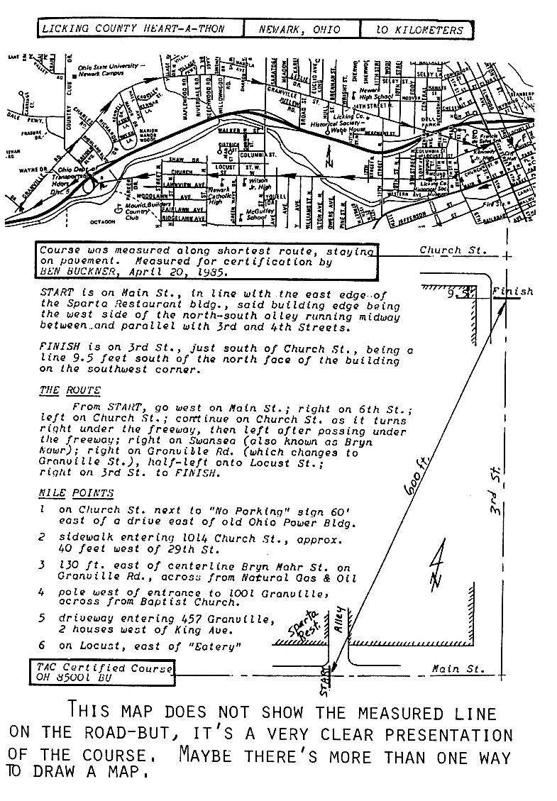
Streets, Google, National Geographic and Route 66 are all neat products, but maybe an adjustment of the requirements for the map would make the map making, submittal and storage easier. The scale and detail on long courses is generally lost if these maps are squeezed onto an 8-1/2 x 11 sheet. A single line map that shows all the turns onto a different road, combined with a route description (in words), a detailed sketch of the Start and Finish location and more words describing special conditions that prevent using the SPR would provide all the information that is really needed and might be both easier to squeeze onto a letter size sheet and surely easier to draw.
Here is an example of a single-line map of a course. It appeared in Measurement News #18, August 1986 as an example of an alternate style map. A supplemental course description removes any ambiguity about the path used on the roads.


I've certified many courses with maps of this type. A single-line map can be a lot clearer than the line-in-the-middle-of-the-road map, especially when the measurer does not take care to make the measured line take the proper tangents.
Last edited by peteriegel
My criterion has long been that of the "stranger." The map should be good enough so that a stranger could ride in the tracks of the measurer, with no help from anybody on site.

When I have to go somewhere to check a course, I am always armed with a good street map which covers the area in question. This helps me better anticipate when a turn is coming up. Also keeps me from getting lost.
Something may be escaping me because I am not a computer specialist, but I am not sure why getting maps on the internet is such a big deal. One of Mike's objections to his using my digital maps was that most measurers could not prepare them. However, I have just scanned a hand-drawn map with my $100 scanner into a 16-KB gif file and loaded it onto the internet within four minutes. I do not see why most measurers cannot do the same, and email the map with a submission file in Word to the state certifier.They could also email the map to the race director to place on the race web site. Alternatively, the state certifier could do the scanning.
Thank you for pressing this issue. It is so refreshing that a few of the endless possibilities of doing things in a more efficient way are being explored.

To streamline the course listing process seems like a very important task to warrant our full attention. The collective minds within the RRTC can certainly come up with a workable solution to put in place. Simple directions and procedures could then be given to certifiers about e-mail constraints for submissions.

When I read Mike’s comments in MN about a “huge backlog of certificate maps” and broken down scanner sitting at the repair shop for a month, I have to ask, “isn’t there a better way?” Can some of the $3.00 per course listing fee be used to buy a new scanner?

Could regional certifiers be required to have a scanner and create certificate and course map files with certain size limitations? Could a network of certifiers with scanner collect and scan certificates and maps from those without scanners? Could our application to certify a road course be made available in a PDF document similar to our current Measurement Certificate, which we just have to file in the blanks?

We can do better.

Add Reply

Post
×
×
×
×
Link copied to your clipboard.
×