
I had a call from David Katz a few days ago. He sought a reliable source for elevation data. He, like many of us, used to use USGS maps for this, and now uses Google Earth. He wondered whether there was anything better around, and wrote to USGS. He received the following reply:

Thank you for contacting the USGS Earth Resource Observation Science (EROS) Center!

To determine the latitude, longitude and elevation of your specific area, go to the following website: Seamless Data Warehouse - http://seamless.usgs.gov

Click on the ?Seamless Viewer? on the left hand side > Once the map loads, use the zoom tool to locate your area > Under the query heading on the left hand side of the screen, click on the elevation query tool (looks like a ruler next to mountains) the last box on the first row > Then click on your area on the map > Under the map, you will see the latitude, longitude, and elevation of the point you selected.

Let us know if you have any other questions.

I wondered whether this source was any more accurate than USGS Maps or Google Earth and decided on a brief field trial. I used the three methods to determine various elevations. Below are the results I got:


I found the USGS site to be slow and not user-friendly. There were too many choices for me to get my head around. I downloaded the “How to use the National Map Seamless Server” and found it confusing. I am sure that the fault does not lie fully with USGS, but at least partially with my own capabilities.

I invite commentary. For openers I suggest that trying to locate the summit of Pike’s Peak using only the Seamless Viewer would be instructive.

I’m not convinced that there is a significant difference in accuracy between the three methods, but hope that more nimble minds may correct me.
Last edited {1}
Original Post

Replies sorted oldest to newest

Pete,
Are you getting different results from "USGS Map" and "USGS Seamless Viewer" because you are not picking the same exact point? It seems like both of those sources would be using the same data.
For the seamless viewer you could use the "US Grid National Query Tool" which is on the bottom-left under Query. You can convert latitude-longitude to USNG with

http://www.ngs.noaa.gov/cgi-bin/usng_getus.prl

This weekend I'm going to repeat your experiment by finding the latitude, longitude, and elevation of the start and finish of a few of my courses, and then compare the elevations of those lat-long points with the Seamless Viewer result.

Thanks for sharing this tool.
By "USGS Map" I mean old paper maps with benchmarks printed here and there, with noted elevations. This is closer than interpolating between contour lines.

Not putting the cursor in the exact same spot can cause error too, but when a tiny wiggle of the cursor produces a jump in elevation, there's a small program error at work.

Although the aerial photos show what's on the ground, house roofs don't seem to make the elevation change.

I'm sure that some mathematical interpolation is used to calculate an elevation from two or more surrounding data points, but I have no clue how it's done.

I'll be looking forward to seeing your results.

Have you located Pike's Peak yet?
Good research Pete. That report you posted has a lot of good information.
I haven't read through the whole thing yet, but I can see that the part most relevant to us is the section on relative accuracy. While the absolute accuracy of a single point is 2-3 meters, the mean error of the elevation difference of two points about 2200 meters apart is 1.64 meters. And the mean error of the elevation difference of two points 90 meters or less apart is only 0.78.
This relative accuracy is what matters when determining a start to finish drop.

I'll include Pike's Peak as one of the points I look at.
For Pike's Peak I get
Google Earth: 14133 feet
Seamless Viewer: 14117 feet
N38-50-26.19 W105-02-39.79

For a point 250m away
Google Earth: 13996 feet
Seamless Viewer: 13982 feet
N38-50-30.35 W105-02-48.60

Elevation difference between the two points
Google Earth: 137 feet
Seamless Viewer: 135 feet

The "US Grid National Query Tool" I mentioned above doesn't give you the elevation, but it does put crosshairs on the location. If you zoom in and click on it you are within 0.1 seconds of the Google Earth location.
Last edited by Admin
I had an awful time with Pike's Peak. The search function on the seamless viewer was unable to find it. I had trouble even having it find Denver for me.

I finally cheated my way to Pike's peak by finding the latitude and longitude by Google Earth, and then inputting those figures into the seamless viewer.

Were you able to locate Pike's Peak using the seamless viewer alone?
I checked the 774 and the 6303 elevations using Google Earth, and the exact stated lat/long. I obtained the exact same results.

The error inherent in the use of third-party elevations has obvious implications where records may be concerned, especially when the differences are "on the cusp" and close to the allowable elevation difference.

The difference can be obtained with greater accuracy if a level survey is conducted, but this is generally not feasible.
If the same source is used for both Start and Finish locations, does the accuracy of elevation really matter?

If I have a drop of 10 meters from Start to Finish, does it matter if I peg my Start elevation at 2100 meters or 2140 meters, and finish at 2090 meters or 2130 meters, respectively? If I use a GPS that calculates elevation through barometric pressure, I get a different elevation at the same location on different days. It can vary from morning to evening, if the weather is changing.

I think that if the same source is used for both locations, it doesn't matter how "correct" it is. It is the relative difference we are looking for.
A look at the article “Vertical Accuracy of the National Elevation Dataset,” cited in my post of August 13, reveals that the relative vertical accuracy of two points is given as 1.64 meters, with a standard deviation of 2.08 meters. This indicates in my mind that I can expect an error averaging about 5 feet (for elevation difference of two points)if I use Google Earth or any product depending on the base USGS data.

The only time this is likely to be a problem is when the drop of a course is near 1 m/km. If I measure a 10k, and get an elevation difference of 9 meters using USGS data through Google Earth, that’s great. But if the error of the method amounts to 1.6 meters, is my course really within record limits?

Moreover, suppose a record is set on the course. The validator looks at the drop. If he uses Google Earth there may not be a problem. Or there may – I don’t know. If one reads an elevation using Google Earth, will one get the same value six months later?

I would hate to see us get into an SCPF for Drop and Separation. It would be a can of worms. Instead, I’d suggest that if one is really concerned, it would be wise to print out a screen shot of the Google Earth areas of start and finish. These, unless proven wrong, would be the readings that count. And proof of wrongness would require either a level survey or use of Google earth with an allowance for error of 4 or 5 meters.

This is a tiny problem and I see no reason to turn the world upside down over it.
Mark, I didn't mean that the elevation was not important. I meant that if my difference in elevations between the two points is 10 meters, that it doesn't matter if the reported elevation of my points are 2010 and 2000 meters, or 1980 and 1970 meters - the difference is still 10 meters.

I also agree with Pete, that the only time it will be a factor is when the drop is very near 1m/km. Then, verification from multiple sources may be in order.
What multiple sources? Are they more accurate than USGS data? I don't think requiring a level survey would fly, and that's the only thing that would produce greater accuracy.

As far as I am concerned, it would not harm things if the Google Earth or USGS reading was taken to be absolutely accurate. All alternatives seem worse.
Good research from all.
But here's the situation- I have a event with a course that could possibly produce American or World Records. The drop is on the "cusp" at .98 m/km! A change in elevation at the start or finish of 2-3 feet will send it over the limit. And I may not have the flexibilty to shift the course. I am in the process of getting the elevation data from the municipality - but this is not always easy.

Different sources give different elevations.
I propose that the measuring community adopt "acceptable sources" for elevation.
Like most, I use Google Earth to determine the start and finish elevations. It's fast and easy to use.

For greater detail, you could use one of the numerous tools created by the USGS. One of the tools is National Map Viewer.

http://viewer.nationalmap.gov/viewer/

The viewer seems to be accurate to the 100ths of a foot/meter. The example below shows an elevation of 104.71 feet / 31.92 meters for the USA Track & Field New England Association office. If the location marker was not in the desired location, you can use the spot elevation button and click elewhere on the map. Spot elevations appear to be accurate to 1 feet or 1 meter.


Click on the image to enlarge.

If the calculated drop was on the "cusp" of being legal, I might include the elevation source on the map.

Thank you. -- Justin
The problem with deferring to Google Earth is that those elevations seem to be based on surveys done in the past, whether the late-1800s, the national 1927 survey, or something in the 1950s. The reason I say this is, I mapped a course that went across a dam. Google Earth showed the original contour in the Elevation Profile. It is a flat road, but the profile shows a high point of 5656', and a low point of 5590'. Not accurate.

But, I would say that if one used GE for elevations in close proximity to one another, and there had not been lots of dirt moved to create the grade (how would one really know that for sure?), then the elevations would likely be relative to one another, whether precise, or not.
A discontinuity will occur here. A very long email discussion has just taken place involving mainly the Eastern certifiers and some others (although most of the Western certifiers won't have seen it). The email discussion was on the topic of suggested guidelines that Duane prepared on how to complete certificates. The discussion focused mainly on drop and separation -- how many decimal places to write, and how accurately we can obtain them. It was suggested that we continue the discussion here, by copying emails to this board, so I will do that. This will be a very long post, as I will copy a number of emails here.
_____________________

We have a number of issues here: How much accuracy can we obtain in calculating drop and sep, and how much accuracy do we need in these values? Also, as one aspect of the first issue, a reason why some people may resist Duane's rounding suggestion is that he proposes rounding not only the final result of drop & sep calculations, but also rounding some of the intermediate results which, in some cases, may significantly alter accuracy of the final result.

I'll start with this matter of rounding intermediate results. For example, Duane suggests rounding the individual Start and Finish elevations to whole meters before computing Drop. As an analogous situation, have you ever considered why, in measuring courses, we work with a "constant" in counts/km (or counts/mile) instead of alternative measures such as counts/meter or meters/count. Conceptually, these alternative measures are just as good for illustrating the principle of wheel measuring. But, in practice, if you worked in counts/meter or meters/count, you probably wouldn't carry enough decimal places, and because of that intermediate rounding, your final result would be totally inadequate for the purpose of course certification.

As a result of Duane's suggestion to round individual elevations to whole meters before computing drop, the drop computed this way may not agree (to a desired number of decimal places) with the drop computed from original elevation data without intermediate rounding. As one possible solution, assuming original elevation data were in feet, I know that some of you will suggest simply leaving them in feet when writing the certificate. For myself, I'll always convert to meters. However, I may need to reduce the amount of intermediate rounding to obtain good enough agreement of the calculated drop. For example, rounding those individual elevations to half-meter precision instead of whole meters may do the trick.

Regarding Justin's suggestion about significant figures, the calculation methods on the indicated website -- http://calculator.sig-figs.com/ -- can be considered a "quick and dirty" method that often keeps roughly the correct number of digits consistent with accuracy of the data. For the case at hand, however (drop and sep), it's easy enough to do a somewhat more rigorous uncertainty analysis, as opposed to the quick & dirty sig fig method. I won't present the analysis here (I may do so in a later message). But as results, I conclude that if elevations come from a source like Google Earth, we can justify only one decimal place for short courses like 5 km although, using the same Google Earth elevations, we can probably justify two decimal places for a long course such as a marathon.

As far as I know, nobody has mentioned this interaction with the course length. Of course, the best way to improve the accuracy of calculated drop is to have more accurate elevation data to start with. But, for elevation data of given accuracy level, we get more accurate drop results for longer race courses.

How accurate do we need the calculated drop to be? In most cases, I see no reason to go beyond one decimal place. But if the drop is very close to the 1 m/km limit, it's reasonable to try for a 2nd decimal place. Doing this in a meaningful way may, however, require more accurate elevation data than we usually have available.

Turning to separation, we get two very different sorts of situations. On the one hand, when start and finish are close together, the distance between them may have been taped, and is therefore known very accurately. In these cases, we can, in principle, compute the percentage separation with considerably better than one decimal place, although I see no reason why we'd need that information. On the other hand, when separation is larger, the figures supplied by measurers are often very rough estimates. For example, a measurer may write something like a "quarter-mile" or "half-mile" which are just rough guesses.

In the first case, when the start-finish distance has been taped, I suggest writing this accurately known distance in the "Straight line distance between start & finish" space -- in meters and not rounded to whole meters. Writing this distance accurately does no harm, and in some cases (e.g., a loop course with separated start and finish), it can be the crucial information needed to set up the course accurately (in such a case, it's presumably also on the course map, but it does no harm to document it in this additional place).

While I would write the "Straight line distance..." with enough digits to match the accuracy available, I can't see any reason why we'd want more than one decimal place in percentage separation values. The only case where we might be tempted to write more than one decimal place is when the separation is extremely small (but non-zero), because we shouldn't enter the separation as exactly zero unless the course truly has a common start/finish. But there's a simple solution for this case: For any non-zero separation which is less than 0.1%, simply round it upward to 0.1%. And, by the way, I seem to recall that Ken Young used this approach in the course list long ago.

For the case of large separations, when a measurer has provided only a rough estimate, I also tend to disagree with Duane's recommendation to round the "Straight line distance" to whole meters, but for an opposite reason. For example, if the measurer estimated a "quarter-mile," the metric conversion in whole meters (402 m) would overstate the accuracy. So, instead, I might round it to 400 m or 0.4 km.

For these courses with large separations, the most accurate way to determine the separation (short of professional surveying) is probably with a tool like Google Earth. But even if this is done very carefully, it's probably not practical to determine the percent separation with even one decimal place; i.e., we'd probably just have to express the separation as a whole number. If the separation turns out to be very close to 50%, and we can't resolve it ourselves, the only solution may be professional surveying.
_________________________

I'd like to expand a little on the long message I sent last night. In connection with separation, I wrote near the end that for large separations, the best we can do (short of professional surveying) is with a tool like Google Earth, and when doing this, we probably can't get the percent separation better than whole numbers. After sending this, it occurred to me that we may be able to do better if we have coordinates from consumer-level GPS devices. To compute the straight line (or more generally, great circle) distance between two points with known latitude and longitude, there are various calculators, e.g., see http://www.movable-type.co.uk/scripts/latlong.html

I'll illustrate with course CO11036DCR which is an interesting case I happened to discover by doing a search for courses with Drop entered as exactly 1 m/km (but my comments here will be about the separation of this course, not its drop). As one interesting aspect, it's listed incorrectly in the database as a 5 km course although it's really a 5 mile course (Gene, you need to fix this). As another error, the cert number written on the map is CO10036DCR although it's really CO11036DCR. You can view the map and certificate at http://www.usatf.org/events/co...?courseID=CO11036DCR Duane helpfully provides GPS coordinates on the map. From the start and finish coordinates, the calculator cited above provides straight line distance 5.087 km. And since it's a 5 mile (8.04672 km) course, the separation works out to 63.2%. I also obtained a very similar result from Google Earth. On the certificate, the straight line distance was entered as 5430 m and the separation was entered as 67.5%.
________________________

Interesting note about using Google Earth in checking separation: When checking a "Line" distance in Google Earth, it displays two distances now, both "Map Length" and "Ground Length." This appears to be a new feature that I hadn't noticed before. My interpretation is that "Map Length" is the distance calculated from latitude and longitude along a surface at mean sea level, while "Ground Length" is adjusted for altitude. At the altitude of Denver, the Ground Length is about 1.00025 times as great as the Map Length. Of course, the difference between these figures is less than the SCPF we use in measuring the course distance.
________________________

To Bob T, Mark, etc.

I think it's pretty clear what the "Ground" length in GE means. First, as you can tell, it's purely a two-point measurement; it's calculated entirely from coordinates of the two endpoints, and doesn't pay any attention to what's in between. But when it calculates this two-point distance, it takes account of two kinds of elevation effects:

1) The Pythagorean slope effect if there's a noticeable elevation difference between the two points. That's what you demonstrated, Bob, in your example with a 134 m elevation difference over a horizontal distance of about 800 m.

2) The effect of being farther from the center of the earth (even when both points are at the same elevation), so that a given angle from the center of the earth (i.e., given change in latitude & longitude) subtends a greater arc distance. Here, the ratio of distance covered, compared with distance at sea level, is roughly (R+h)/R where R is the radius of the earth and h is your elevation above sea level.

The second effect is the one I had in mind when I wrote that in Denver (elevation about 1.6 km), ground distances are greater than map distances by a factor of about 1.00025. It also explains your second example, Bob, assuming that both points are at about 250 m elevation.

In that 2nd example (with elevation change about 7 m in horizontal length about 3772 m), the Pythagorean effect amounts to only about 6 mm, and you don't need a super calculator to show it. You can get it from the approximation that if "a" is much greater than "b" then:
sqrt (a^2 + b^2) is approximately a + (b^2)/(2a)
where it should be noted that the small size of the (b^2)/(2a) term is the reason why the "offset" technique we often use while measuring (to avoid riding dangerous tangent lines) is effective.

To David:

Yes, we need to seriously investigate the sources of drop and separation data to provide the data needed to support records.

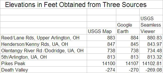
For drop: My feeling is that GE is probably good enough for most cases, when drop isn't very close to the 1 m/km limit. For drop closer to 1 m/km, it may still be good enough for longer courses (e.g., marathons) but it breaks down for shorter courses (e.g., 10 km). The USGS national map viewer at http://viewer.nationalmap.gov/viewer/ is probably a little more accurate than GE. Among other sources, I don't have much feel for accuracy of elevations from consumer-level GPS, but my hunch is that they're not as good as Google Earth or USGS. I also don't have any feel for accuracy of elevation data that municipal agencies may have (which you said you'd try using, David). The ultimate accuracy would be by professional surveying.

For separation: I think GE and latitude-longitude coordinates from consumer-level GPS are both pretty good, and can probably settle the matter in most cases. But if it's really close to the 50% limit, professional surveying may be required.
More on the latest Google Earth tweak
Again very well stated, Bob. What occurs to me now is that many of us have been noticing that even when you get great closeup views, Google Earth has been stating course length a bit on the low side. Maybe because distance has hitherto been calculated for mean sea level? Will the "ground level" measurements be a whole lot closer to our (Jones-Riegel counter) results?
About very small start-finish separation: I like that, rounding to 0.1%. Or we could say "<0.1%".
Here's yet another way to get 'super accurate' elevations from the USGS Elevation Service. If you know the exact GPS coordinates, you can find the elevation in meters or feet.

I used the USATF New England Association Office for this example. Google Earth says the decimal coordinates are latitude 42.335895° and longitude -71.149826°.

I went to the USGS Elevation Service web page.

http://cumulus.cr.usgs.gov/XML...asmx?op=getElevation

I was prompted for several values....

X_Value (Longitude): -71.149826

Y_Value (Latitude): 42.335895

Elevation Units (feet or meters): meters

Source_Layer: NED.CONUS_NED


Click on the image to enlarge.

It will return an XML file containing the elevation of 32.7786979675293 meters.

<USGS_Elevation_Web_Service_Query>
<Elevation_Query x="-71.149826" y="42.335895">
<Data_Source>NED 1 arc-second: Contiguous United States</Data_Source>
<Data_ID>NED.CONUS_NED</Data_ID>
<Elevation>32.7786979675293</Elevation>
<Units>METERS</Units>
</Elevation_Query>
</USGS_Elevation_Web_Service_Query>


Click on the image to enlarge.

You can experiment with the values. Try entering -1 as the Source_Layer and -1 as the Elevation_Only values. The data source will change from a 1-arc second to 1/3-arc second source.

The elevation has 13 decimal places. I cannot imagine an elevation that accurate (1 micron is 1 x 10^-6 meters), but it may be a useful resource.

Google Earth said the elevation at those coordinates is 32 meters.

Thank you. -- Justin

ps. I stumbled on an iPhone Elevation App that makes use of the USGS Elevation Service.


Click on the image to see more.
Last edited by justinkuo
Awesome, Justin. However, even just to 3 or fewer decimal places - for what applications might we need this method? As you say, Google Earth does a good job. Are we contemplating situations where Google Earth is insufficiently accurate?

Are there scientific studies that demonstrate that courses with sep/drop >1m/km produce significantly faster times than courses with a drop of say, 0.9 m/km? The (apparent to me)absence of some rigorous scientific criteria on which to base the drop/sep number indicates that for a situation like Dave Katz's, we could consider modifying the criterion instead of finding the exact measurement. For instance, why not a criterion such as "1m/km plus or minus 5%"?
Even using the USGS site, I still question the accuracy of elevation values where there has been grade-changing earthmoving work. I will refer, again, to measurements crossing a dam.

Using the GPS coordinates for two mile points, from the USGS site I get 5572' for a GPS coordinate which was taken on the dam itself, and 5517' for a point below the dam. The same two points, taken from Google Earth, show elevations of 5653' for the higher point (which shows on GE as being on the dam road, just as I measured it), and 5521' for the lower point.

That's a difference of 81 feet for the point "on the dam road", and 4 feet below the dam. This leads me to conclude that the USGS data is from old surveys/topo maps, and does not necessarily reflect man-altered ground elevations.

Which gets back to my point of "how do we know the source of our elevation data is accurate?". Just because it is the USGS, or a Topo map, or GE, for that matter, does not mean our Start and Finish values are correct. Thus, our desire to round to two decimal points, or to use fractions of a meter, may be incorrect assumptions of accuracy (unless converting elevations submitted in feet). If you can see both points, and it looks like the values could be correct (if one location appears to be 3 feet lower than the other, for instance, and GE or USGS validates that observation), then by all means, we can accept it as accurate in relation to each other. But, if you can't see both locations from one spot, and there may have been elevation changes made for construction (malls, ball parks, even parks that sit on top of old landfills), we certainly can't vouch for the accuracy of our elevation values.

Even GPS units, for the casual consumer grade unit, can't be relied upon to be accurate, even relative to its own reading on the same course. I used to use a "high-def antenna" unit (Garmin e-trex Venture, or something like that), which used the satellites for elevation calculation. I could ride a course with the same Start/Finish location, and my elevations could be off by 20 feet for the same Start/Finish spot. I now use a Garmin Oregon 450 which uses barometric pressure for elevation. Even those are usually not the same at each end of a ride that began and ended at the same location.

Greater accuracy of elevation reading may be achieved by letting the GPS unit sit still for at least 5 minutes on each point, but most of us don't take that time. A unit I use for my day job must be on-point for 10 minutes before it is accepted by the State for location and elevation readings.

My whole point is that we cannot be sure of our elevation values, unless we have a survey-grade unit, and use it according to proper operating procedures. These cost over $35k, and take multiple units. We don't have that equipment, nor is our use worthy of such accuracy.

Let's simply state that elevation values are approximate, and let it go at that. If the Records committee needs greater accuracy, they can hire a surveyor to do the work. Until then, our elevations will be approximate, based on whatever resources we choose to use.
The National Elevation Dataset (NED) is the primary elevation data product of the USGS. It's updated on a two month cycle and is derived from a variety of sources. NED data is available nationally (except for Alaska) at resolutions of 1 arc-second (about 30 meters) and 1/3 arc-second (about 10 meters), and in limited areas at 1/9 arc-second (about 3 meters). [That's the horizontal resolution.] A wealth of information on the National Elevation Dataset is available at the link below.

http://ned.usgs.gov/

There is also a study on the vertical accuracy of the National Elevation Dataset available at

http://ned.usgs.gov/downloads/...nts/NED_Accuracy.pdf

I will need someone to explain the complete study, but it appears in a test of 9,187 unique point pairs, the relative vertical accuracy (RV) was 1.64 meters.

So, it appears if we use the National Elevation Dataset to determine the start and finish elevations, we can be reasonably certain they are accurate within 1.64 meters. Is that accurate enough to calculate the drop for record purposes? Probably.

Thank you. -- Justin
That's the report that Pete provided a link to earlier in the thread.

Those 9000+ points had a median separation of 2200 meters, and the standard deviation of their relative elevation error was 2.08 meters, so the 95% confidence level (approximately 2 standard deviations) is 4.16 meters.

The standard deviation of the elevation error (not the relative error) for the points is 2.44 meters. If we subtract a distribution with a standard deviation of 2.44 from another distribution with the same standard deviation, the result is a distribution with a standard deviation of 3.42. This is the standard deviation of pairs of points that are essentially infinitely far apart.

So in summary we have

Distance apart: 95% confidence level
0 meters: 0 meters
2200 meters: 4.16 meters
very far apart: 6.84 meters

In addition, you would expect the standard deviation of the error at 90 meters separation to follow a similar pattern as the mean error at 90 meters separation. This would give us an additional point of

Distance apart: 95% confidence level
0 meters: 0 meters
90 meters: 1.98 meters
2200 meters: 4.16 meters
very far apart: 6.84 meters

A function of the form

error = 6.84 X exp(c1 x separation ^ c2)

can be fit to this data.

The result can be used to make an estimate of the accuracy of the drop value for different course lengths as shown below.

Impressive analysis, gentlemen.

However, I admit my ignorance about the 1m/K drop criterion. It seems our concern in this discussion about elevation accuracy is predicated on this measurement being super accurate. What is "magical" about the 1m/K calculation?

Of course, there must be some some standard for net elevation drop. Is there science behind this criterion?
It’s surprising that the question of elevation error was not recognized long ago, but here we are. We have a conflict between what we can do and what the “drop” rule requires.

With regard to course length, we instituted the Short Course Prevention Factor, which is easily applied by the measurer when the course is laid out. It provides reasonable assurance that the course is not short of its nominal length. Validations have shown that it works.

With regard to elevations, the only practical tool we have is published elevation data. This has historically been obtained from topographical maps, and lately through the use of Google Earth and other online tools which allow estimation of elevation data. Now we are belatedly aware that the error in the elevation data may create problems in determining whether course drop exceeds the limit. What can we do about it?

A level survey conducted between start and finish can provide a closer estimate of the difference than can examination of maps and online sources. It is highly unlikely that anyone would seriously consider doing this, as it can be time-consuming, expensive, and outside the competence range of anyone except a professional surveyor. I don’t consider it a reasonable tool, and think that making it a requirement is not a smart thing to do.

So where are we? We lay out a course with a route specified by a race director. We add the SCPF, and when we look at the end points we estimate their elevations. In the vast number of courses these elevations are of little interest to anyone, as records are quite rare.

In spite of the error ranges which have been discussed it remains a fact that the elevations obtained by maps or Google Earth represent the most probably correct values, if one must pick a single value.

I see this as a problem for the USATF Records Committee, and I would recommend that they accept images of maps or screen shots of Google Earth as absolutely correct. There is no practical alternative that I can see. As far as I know elevations have been taken at face value as long as road records have been kept by USATF.

In short, I recommend that nothing be done.

The thing that started this discussion was an inquiry by David Katz, who was concerned that a course had a drop very close to the limit, and who was concerned that validation might find the course drop over the limit. He considered a record to be somewhat probable given the quality of the field. In this case I’d recommend that he arm himself with documentation that supports the claim that drop is within the limits, and that the Records Committee accept this at face value.
I agree with Pete.

But I think if we are asking the records people to accept our drop values at face value then we should require that those drop values use elevations directly from USGS data anytime the google earth drop calculation ends up between 0.5 and 1.5 m/km. At least we have some information telling us how accurate the USGS data is. We have next to nothing telling us how accurate GE elevation data is.

This is not asking much. I would guess the drop ends up between 0.5 and 1.5 about 5% of the time, and looking up the elevations with the link that Justin provided is very easy and very straight-forward. It's a lot less work than what folks had to do before GE was available.
Pete, I think what Lyman is referring to here is the precision issue. Say a course has a drop of 1.001m/km based on the elevation figures obtained, to we bounce it from record consideration?
My own feeling would be if it's close to the limit one way or the other, look into the elevation figures more closely and perhaps consult other sources. Otherwise, don't fret it.
Thanks, Jim. Yes, this is what I was getting at, if obliquely. I read the science behind the 1m/km rule, and I believe I understand it. What I do not understand is what the margin of error should be. Given the apparent inexactitude of elevation data, shouldn't we adopt some standard of flexibility? Also, it seems to me that, though there is good reasoning to establish 1m/km, this is still subject to a margin of error, isn't it?

Courses that have a lot of uphill in addition to the net drop are certainly not the same as 1m/km drop or more courses that have few if any uphills, right? I know of a 10K course with a 70-foot net drop that has jaw-dropping uphills. I imagine this phenomenon has been thoroughly discussed elsewhere. I bring this up to say that it seems to me that there is enough of an arbitrary element to the numbers that seeking precision here does not seem productive to me. Too many unquantifiable variables. My two cents.
Lyman,

There's lots of evidence that 1 m/km net drop provides substantial aid, at least for runners smart enough to take advantage of it. As specific articles to read, I'll start with one that wasn't in Measurement News, but rather in NRDC News, namely, the January 1986 issue available in the NRDC News archive at http://www.runscore.com/coursemeasurement/NRDCNews/ where you should read Ken Young's material. The drop limit had been set originally at 2 m/km in 1983 when rules for US Road Records were first established. But in this 1986 article, Ken recommended reducing the drop limit to 0.4 m/km, which would have made sense according to the principle that the aid provided by elevation drop shouldn't be much greater than the uncertainty in time resulting from uncertainties in measurement of the course length. Politically, however, it wasn't possible to reduce the limit lower than 1 m/km, which is the revised limit adopted in 1989.

Regarding your point about courses with a lot of uphill in addition to a net drop, I suggest reading a bunch of articles in the Measurement News archive at http://www.runscore.com/course...ent/MeasurementNews/ Start with my article "Hill Effect to Second Order" in the January 1989 issue (MN 33), then an article with the same title by Alan Jones in July 1989 (MN 36), and also the article "Uphills, Downhills and the Boston Marathon" by Alan Jones and myself in March 1990 (MN 40) -- and see also Pete's "PACE CHART FOR BOSTON MARATHON" in that issue. For still more comments, see my article "Understanding Aidedness--The Effect of Drop" in March 1991 (MN 46). All of these calculations show that, for most courses, the effect of the uphills doesn't significantly reduce the aid provided by the net drop.

Your comments about "margin of error" reminded me of our debates in the 1980s (in a different context) about "Allowance for Error in the Validation Measurement" (AEVM). In that case, RRTC adopted a policy (announced by Pete Riegel in Nov 1989 Measurement News - MN 38) that a course would "pass" validation if the remeasurement came out short by as much as 0.05%. That AEVM was thrown out in 2007, when RRTC's validation procedures were modified to match those of IAAF.

When considering the science on any of these topics, the situation tends to be somewhat fuzzy, and we may often express uncertainties using two-sided (plus or minus) tolerances. However, for the purpose of record keeping in athletics, although the rules acknowledge measurement uncertainties, tolerances are always one-sided: Field event implements must weigh at least the amounts specified; courses must be at least as long as stated; and in the case of elevation drop, the drop must not exceed a specified limit. The official rules relating drop to record eligibility are:

USATF Rule 265.5(a): The course must not have a net decrease in elevation from start to finish exceeding 1 part per thousand (i.e., 1m per km).

IAAF Rule 260.28(c): The overall decrease in elevation between the start and finish shall not exceed 1:1000, i.e. 1m per km.

The USATF rule has been on the books since 1989 and the IAAF rule nearly as long (since IAAF began keeping world road records). We can't expect these rules to be changed. We've realized now that the elevation data we customarily obtain isn't always adequate to determine unambiguously whether a course's drop is less than or greater than the 1 m/km limit. In such cases, if record considerations arise, we must simply do our best to obtain better elevation data and try to determine whether the course meets the record eligibility criterion.
PERFECT VS GOOD ENOUGH

It’s pretty obvious that all the drop-separation analysis has been based on somewhat approximate science. If we had had a giant database to work with it might have been possible to do a better job. However, there were some non-scientific aspects of the problem that were considered.

If the only goal was to create courses on which records were possible it would be fairly easy to create a single easy-to-understand criterion for a record-quality course. All it would take would be to require that start and finish be located in the same place. In other words, only closed-loop and exact out-back courses would qualify. This would leave wind aid as a possibility, but would eliminate downhill aid. It would also eliminate the vast majority of certified courses from record consideration.

When the search for criteria was going on, consideration was given to inclusiveness. It was seen as desirable that the end result should not shut out too many courses from record consideration. When the dust had settled on all the scientific arguments, it was seen that the present record limits included about 90 percent of all certified courses.

Given the complexities and uncertainties of setting up record criteria for road courses I believe that what we have is good enough.
Bob, thank you for the detailed explanation. Anecdotally, as a runner, I had always believed "you can never make up completely the time advantage you lose on uphills with the time advantage you gain on downhills" - at least, in a (theoretical) situation where the elevation changes are equal. Your recounting of the downhill advantage analysis would seem to put the lie to this belief. Maybe it is different for elite runners than for recreational runners like me. I ran all my lifetime PRs on flat courses. I always felt the % slowing going uphill exceeded the % accelerating going downhill in my races.

I agree with Pete that "the pursuit of perfection is the enemy of good enough", meaning that it seems there is enough "wobble" in the criteria data to obviate establishing exact elevation standards. We are considering athletic performances by human beings, after all, not Newtonian phenomena of nature, right? The unquantifiable - beyond broad measures - nature of these things even makes me question the need for one-sided tolerances.
Last edited by pastmember

Add Reply

Post
×
×
×
×
Link copied to your clipboard.
×