Thank you for contacting the USGS Earth Resource Observation Science (EROS) Center!
To determine the latitude, longitude and elevation of your specific area, go to the following website: Seamless Data Warehouse - http://seamless.usgs.gov
Click on the ?Seamless Viewer? on the left hand side > Once the map loads, use the zoom tool to locate your area > Under the query heading on the left hand side of the screen, click on the elevation query tool (looks like a ruler next to mountains) the last box on the first row > Then click on your area on the map > Under the map, you will see the latitude, longitude, and elevation of the point you selected.
Let us know if you have any other questions.
I wondered whether this source was any more accurate than USGS Maps or Google Earth and decided on a brief field trial. I used the three methods to determine various elevations. Below are the results I got:
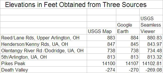
I found the USGS site to be slow and not user-friendly. There were too many choices for me to get my head around. I downloaded the “How to use the National Map Seamless Server” and found it confusing. I am sure that the fault does not lie fully with USGS, but at least partially with my own capabilities.
I invite commentary. For openers I suggest that trying to locate the summit of Pike’s Peak using only the Seamless Viewer would be instructive.
I’m not convinced that there is a significant difference in accuracy between the three methods, but hope that more nimble minds may correct me.