I had a call from David Katz a few days ago. He sought a reliable source for elevation data. He, like many of us, used to use USGS maps for this, and now uses Google Earth. He wondered whether there was anything better around, and wrote to USGS. He received the following reply:

Thank you for contacting the USGS Earth Resource Observation Science (EROS) Center!

To determine the latitude, longitude and elevation of your specific area, go to the following website: Seamless Data Warehouse - http://seamless.usgs.gov

Click on the ?Seamless Viewer? on the left hand side > Once the map loads, use the zoom tool to locate your area > Under the query heading on the left hand side of the screen, click on the elevation query tool (looks like a ruler next to mountains) the last box on the first row > Then click on your area on the map > Under the map, you will see the latitude, longitude, and elevation of the point you selected.

Let us know if you have any other questions.

I wondered whether this source was any more accurate than USGS Maps or Google Earth and decided on a brief field trial. I used the three methods to determine various elevations. Below are the results I got:
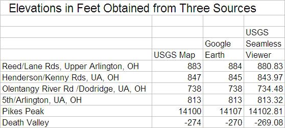


I found the USGS site to be slow and not user-friendly. There were too many choices for me to get my head around. I downloaded the “How to use the National Map Seamless Server” and found it confusing. I am sure that the fault does not lie fully with USGS, but at least partially with my own capabilities.

I invite commentary. For openers I suggest that trying to locate the summit of Pike’s Peak using only the Seamless Viewer would be instructive.

I’m not convinced that there is a significant difference in accuracy between the three methods, but hope that more nimble minds may correct me.
Last edited {1}
Original Post

Replies sorted oldest to newest

Pete,
Are you getting different results from "USGS Map" and "USGS Seamless Viewer" because you are not picking the same exact point? It seems like both of those sources would be using the same data.
For the seamless viewer you could use the "US Grid National Query Tool" which is on the bottom-left under Query. You can convert latitude-longitude to USNG with

http://www.ngs.noaa.gov/cgi-bin/usng_getus.prl

This weekend I'm going to repeat your experiment by finding the latitude, longitude, and elevation of the start and finish of a few of my courses, and then compare the elevations of those lat-long points with the Seamless Viewer result.

Thanks for sharing this tool.
By "USGS Map" I mean old paper maps with benchmarks printed here and there, with noted elevations. This is closer than interpolating between contour lines.

Not putting the cursor in the exact same spot can cause error too, but when a tiny wiggle of the cursor produces a jump in elevation, there's a small program error at work.

Although the aerial photos show what's on the ground, house roofs don't seem to make the elevation change.

I'm sure that some mathematical interpolation is used to calculate an elevation from two or more surrounding data points, but I have no clue how it's done.

I'll be looking forward to seeing your results.

Have you located Pike's Peak yet?
Good research Pete. That report you posted has a lot of good information.
I haven't read through the whole thing yet, but I can see that the part most relevant to us is the section on relative accuracy. While the absolute accuracy of a single point is 2-3 meters, the mean error of the elevation difference of two points about 2200 meters apart is 1.64 meters. And the mean error of the elevation difference of two points 90 meters or less apart is only 0.78.
This relative accuracy is what matters when determining a start to finish drop.

I'll include Pike's Peak as one of the points I look at.
For Pike's Peak I get
Google Earth: 14133 feet
Seamless Viewer: 14117 feet
N38-50-26.19 W105-02-39.79

For a point 250m away
Google Earth: 13996 feet
Seamless Viewer: 13982 feet
N38-50-30.35 W105-02-48.60

Elevation difference between the two points
Google Earth: 137 feet
Seamless Viewer: 135 feet

The "US Grid National Query Tool" I mentioned above doesn't give you the elevation, but it does put crosshairs on the location. If you zoom in and click on it you are within 0.1 seconds of the Google Earth location.
Last edited by Admin
I had an awful time with Pike's Peak. The search function on the seamless viewer was unable to find it. I had trouble even having it find Denver for me.

I finally cheated my way to Pike's peak by finding the latitude and longitude by Google Earth, and then inputting those figures into the seamless viewer.

Were you able to locate Pike's Peak using the seamless viewer alone?
I checked the 774 and the 6303 elevations using Google Earth, and the exact stated lat/long. I obtained the exact same results.

The error inherent in the use of third-party elevations has obvious implications where records may be concerned, especially when the differences are "on the cusp" and close to the allowable elevation difference.

The difference can be obtained with greater accuracy if a level survey is conducted, but this is generally not feasible.
If the same source is used for both Start and Finish locations, does the accuracy of elevation really matter?

If I have a drop of 10 meters from Start to Finish, does it matter if I peg my Start elevation at 2100 meters or 2140 meters, and finish at 2090 meters or 2130 meters, respectively? If I use a GPS that calculates elevation through barometric pressure, I get a different elevation at the same location on different days. It can vary from morning to evening, if the weather is changing.

I think that if the same source is used for both locations, it doesn't matter how "correct" it is. It is the relative difference we are looking for.
A look at the article “Vertical Accuracy of the National Elevation Dataset,” cited in my post of August 13, reveals that the relative vertical accuracy of two points is given as 1.64 meters, with a standard deviation of 2.08 meters. This indicates in my mind that I can expect an error averaging about 5 feet (for elevation difference of two points)if I use Google Earth or any product depending on the base USGS data.

The only time this is likely to be a problem is when the drop of a course is near 1 m/km. If I measure a 10k, and get an elevation difference of 9 meters using USGS data through Google Earth, that’s great. But if the error of the method amounts to 1.6 meters, is my course really within record limits?

Moreover, suppose a record is set on the course. The validator looks at the drop. If he uses Google Earth there may not be a problem. Or there may – I don’t know. If one reads an elevation using Google Earth, will one get the same value six months later?

I would hate to see us get into an SCPF for Drop and Separation. It would be a can of worms. Instead, I’d suggest that if one is really concerned, it would be wise to print out a screen shot of the Google Earth areas of start and finish. These, unless proven wrong, would be the readings that count. And proof of wrongness would require either a level survey or use of Google earth with an allowance for error of 4 or 5 meters.

This is a tiny problem and I see no reason to turn the world upside down over it.
Mark, I didn't mean that the elevation was not important. I meant that if my difference in elevations between the two points is 10 meters, that it doesn't matter if the reported elevation of my points are 2010 and 2000 meters, or 1980 and 1970 meters - the difference is still 10 meters.

I also agree with Pete, that the only time it will be a factor is when the drop is very near 1m/km. Then, verification from multiple sources may be in order.
What multiple sources? Are they more accurate than USGS data? I don't think requiring a level survey would fly, and that's the only thing that would produce greater accuracy.

As far as I am concerned, it would not harm things if the Google Earth or USGS reading was taken to be absolutely accurate. All alternatives seem worse.
Good research from all.
But here's the situation- I have a event with a course that could possibly produce American or World Records. The drop is on the "cusp" at .98 m/km! A change in elevation at the start or finish of 2-3 feet will send it over the limit. And I may not have the flexibilty to shift the course. I am in the process of getting the elevation data from the municipality - but this is not always easy.

Different sources give different elevations.
I propose that the measuring community adopt "acceptable sources" for elevation.

Add Reply

Post
×
×
×
×
Link copied to your clipboard.
×