On a bike ride a couple weeks ago I stopped along one of our rail trails to walk into the woods a ways in order to answer nature's call. About 20 feet into the woods I stumbled across this

When I got home I googled it and found a neat website for locating the survey markers.
https://geodesy.noaa.gov/NGSDataExplorer/
On that page you zoom into a particular area of interest on the map, hit the Find Marks button, and it shows you the locations of survey markers in that area.
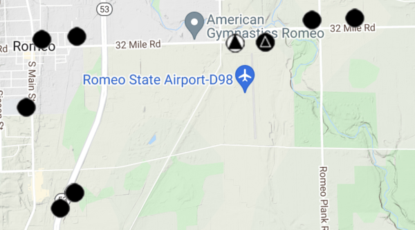
The black circles are "vertical control" markers that have accurate elevation data, but only approximate GPS positions. The marker I had stumbled across was a vertical control marker. The black circle with a triangle inside on the picture above is also a "GPS control" marker with a very accurate GPS position. If you click on any of the markers you can bring up its data sheet that includes its GPS coordinates and an estimate of its accuracy. All the triangle ones I checked had an estimated accuracy of less than 1cm, with 95% confidence.
In subsequent bike rides I have looked for some of these "triangle" markers in my area. I was unsuccessful in finding the first two I looked for. Almost all of them seem to be located fairly close to a road, and I'm guessing that some of them probably get removed during road improvement projects. It says on the web page that the horizontal control markers aren't used much anymore since high-end GPS equipment has become very accurate. So they may not worry too much about them or keep track of which no longer exist.
On my ride today though, I was able to find one of the triangle markers.

I took GPS readings while standing over the marker with both my handheld Garmin and with the MyTracks app on my Pixel 5. The GPS coordinates given by the MyTracks app were about 12 feet off. The ones given by the Garmin handheld were 38 feet off!! Not a good day for my Garmin.
A fun little geocaching activity, and also a good test of the absolute accuracy of whatever device/app you are using to get your GPS coordinates.


 - "GPS and Approx Height" marker near my house using the NGS map you provided. I then located it on Google Street view, where someone has labeled it "JV7109" in white paint on the road next to it.