I need your knowledge and/or opinion. Is it ok to do this?

I may get asked to measure and certify a 5K course on a big air base… on the runway. This is a combination civilian-military base with a 9,800 foot main runway. I’ve talked to the RD, he says air operations will give me a time slice where the runways are all mine to measure with no planes using the runways or taxiways. Today I talked with a committee member and he thinks nobody thought to ask if we could leave any paint markings or survey nails in their tarmac – but the answer is probably “No!”. We will have both concrete and asphalt. I’ve never walked out on the runways there and may not have good physical reference points.

It occurred to me that the simple route appears on Google Earth to be about 200 feet short of an exact 5K. What I’m inclined to do is meticulously define the loop, then certify the 5K as exactly one loop of the defined route plus 200 feet, or whatever the value actually is based on our calibrated Jones Counts.

If we could trust the RD to bring a tape measure then he could place his start line anywhere on the loop and then the finish will need to be setup at a 200 foot overlap of the loop.

I don’t like the idea of trusting an RD to use a tape, but I do like the flexibility of terminus placement and no need for nails and paint.

What's your view? Certified or not it should be an awesome run!

Jeff John
New York
Original Post

Replies sorted oldest to newest

For what it's worth, Jeff, I've had no problem in painting mile marks on the runway for courses like that-- mine was at Dulles. They might not have a problem with paint.

I don't really like the idea of "+ 200'" either, I think it's best to mark the start and finish after a conversation with the RD to see how they want to set it up. Problems I see: 1, there are folks who pick the wrong "0" on a tape-- you don't really know their skill level; 2, the slippery slope problem, if 200 feet is ok for RD to measure, what about 300? 1,000? etc.

My only problems in measuring there came when the "open window" for measurement was drawing to a close and I had several more tasks so I had to hurry like crazy. Got off the runway just in time. Another time, communications hadn't been as effective as planned, and the air traffic control folks were freaking out. "Why is there a man riding a bike on the runway??!!"
Most RD here want a common start and finish point to save the extra cost of the timer setting up two different points or moving mats, so that would seldom be an option here. As Bob stated, there are other reasons a loop plus might not work. Mile points would also never be correct, if they found them. I measured a 5k at O'Hare on a new runway that was not active, but I had airport security with me all the way. I also measured one at Chicago Executive Airport at 3:00 a.m. and had airport maintenance with me who were broadcasting on the ground frequency at every turn. I did not have any problems making smaller paint marks for the start, finish and mile points for both courses. Look or ask for a "Movement Diagram" of the airport. All runways, taxiways and pads are identified and marked and you should have no problem finding landmarks. I am a pilot but I used the airport maintenance supervisor to help develop the description and reference to the landmark, so the lingo was correct. If it works, the attached URL will take you to the sample diagrams for Chicago Executive Airport. The course I measured there is IL18011WR.

Chi Ex Airport Diagram
Cool diagrams Winston.

I don't like the loop +200ft idea either. If there is no tape or wheel handy they might decide 66 paces is close enough.

One type of landmark that you can always count on with concrete surfaces is expansion joints. Nothing wrong with the 12 feet south of the 9th expansion joint south of a taxiway intersection as a description.
Great stuff! Thanks Bob, Winson, Mark. Its encouraging that you were permitted to leave some markings. Winston, I like the airport diagrams - I'll track them down. We may have uncovered a typo and a minor filing error: There is no course yet designated IL18011WR in our database, but I did find the listing for IL18001WR, but, stored as its map instead of the Chicago Exec Airport we currently find the "McCormick Place AACR 5K". Oops. I looked at IL033WR (Run On The Runway) instead, and at Bob's "Dulles Days" 5K and 10K, VA14034RT, VA14035RT.

JJ
Last edited by jeffjohn 2
Jeff, thanks for the catch. I submitted IL18011WR on 4/30/18 and checking with Jane Parks to see what happened.

I couldn't figure out how to upload an image of the course map, but here are the descriptions of the points. All developed by the airport personnel who will be setting up the course, so they should be able to find them.

Start: North edge of taxiway Charlie at expansion joint even with west end of Pad for taxiway C (see detail)
Mile 1: North edge of taxiway Quebec, even with electrical duct plate 1-3”,4”,5” at T-hangar 57
Mile 2: East edge of runway 16, 25' south of line extending perpendicular to “2” end of runway sign
Mile 3: South edge of runway 24, 14' 6” east of 1st runway light east of taxiway Echo
Finish: South edge of runway 24, 26' east of the base of 4th runway light west of approach to runway 24 (see detail

IAG Measure 01 640

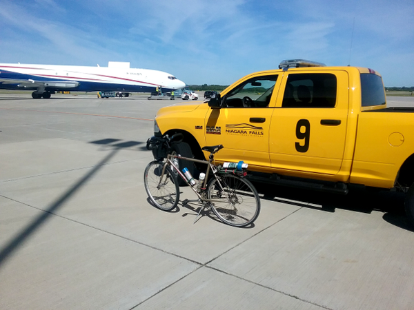
Thanks ALL for sharing your advice and experience on measuring on airport runways!  Thanks to your expertise I was right at home when I arrived at the Niagara Falls International Airport to measure.  It was a GREAT experience!  I met the Airport Manager, and he was fully on board for the planned 5K later this summer.  He assigned a tech to me who shadowed my movements and kept us in contact with Air Traffic Control's Ground Control at all times. 

The civilian airport is shared with the US Air Force Reserve's 914th Air Refueling Wing.  All three runways were active, including the big one, 10L/28R, over 2 miles in length.

I was advised this was probably the 1st time anyone had ever ridden bicycle onto the active runways.

We had to always "hold" short at or before runway hold lines and get permission to cross or enter any runway.  The first hold came at my 1-Mile split. A huge KC-135 stratotanker was readying for takeoff.  The big bird weighs over 100,000 pounds and it was loaded with about 200,000 pounds of fuel for re-fueling ops.  It needed just about the entire 2 miles to get airborne.   Once the KC-135 was airborne, ground control advised that I was clear to "turn right onto runway 10-Left", that's the big one!   Having a runway this big enabled us to design a very simple loop course 5K.   It should be real fast - no hills - very few turns.

On my second measure, we had to hold at various locations, including short of the big runway for an executive jet practicing touch-and-go's.  Then to our surprise, ground control stopped us again before we reached the runway:  A huge US Navy Poseidon P8 had entered our airspace and wanted to practice a rapid touch-and-go in the opposite direction, with the wind, on runway 28 Right.  It was great to watch that up close.

The job took about 3 times longer to complete than a street 5K, but my numbers were real good.  It was an awesome experience!

Jeff John

Attachments

Images (1)
  • IAG Measure 01 640: The measurment bike readying to measure the RUNWAY 5K
Files (1)
Last edited by jeffjohn 2

RaceResources LLC, you could use GPS coordinates for splits, as long as they are not stated as "certified".  GPS coordinates are only as accurate as the instrument that measured them, combined with the instrument trying to locate them prior to the race.  Consumer-grade units are normally accurate to within +/- 10', and some are less accurate.  Descriptions from landmarks are best.

That said, if there is no describable landmark nearby, I do say "use GPS coordinates to get close, then look for marker".  Usually marked with washer/nail, or surveyor whiskers.

Don't use only GPS coordinates for Start, Finish, or Turnaround locations, though.  Those must have a reference to at least one landmark.

Of course not, Duane. Never have, never will use then for Start, Finish, or Turnarounds, except for designating the general area for these points.

What I mean to say is that when the nearest fixed object for a mile mark is many yards away, GPS coordinates in an area without tall buildings, heavy overhead canopy, not or on or beneath bridges are not only a huge help, they are by themselves accurate enough for these non-certified location descriptions. I have noticed that GPS locations seem to be less inaccurate these days than say, ten or even five years ago in my experience.  Part of this is that GPS software is improving, IMO. 

I performed course layout two days ago for a 20K that I certified a few years ago (map is attached). The parks authority allows no paint, nails, or markings of any kind. There is little on the paved bike path part of the course that can be appropriated for fixed object reference except small mileposts on the side of the trail. As I searched for some of these posts, I concluded that two of them had gone missing in the last year. I was left with GPS coordinates and little else with which to locate a couple of the mile marks. I heard no complaints about any of the mile marks following the race.

Doubtless you know that it is often possible to locate a Start, Finish, or Turnaround on Google Earth when you have your exact ground-truthing data for these locations. It is then possible to locate an exact point on GE, then measure from it to a mile mark. This entails locating the exact fixed-object-identified point, then measuring ("Add Path" tool) at highest zoom for curves, and at lower zoom to plot a perfectly straight measuring line where feasible. Set a GE placemark at the interim timing point so located, then use the ruler to mark a small line perpendicular to the running path at this location. Then, when GE has ground level imagery available for the road in question, is is possible to locate fixed objects at ground level. It is then feasible, again using the GE ruler, to identify this object and measure accurately from it to the mile mark. IMO, this method can be perfectly fine for Mom & Pop 5Ks or any race for which +/- 10' is adequate.

I used this for a recent low-key race measurement in which I hurried through my second ride to complete it before a lightning storm arrived. I filled in the three mile marks using this method in an open area with good ground-level imagery, using my fixed-object-identified Start, Finish, and Turnaround. No complaints after the race.

I am interested to know if anyone else has used this method, or if anyone has any reservations about it other than those previously mentioned.

Attachments

Add Reply

Post
×
×
×
×
Link copied to your clipboard.
×