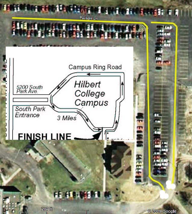
I’ve got two important things to share. I solicit your valuable input:
1) a mapping problem and
2) a possible USATF/RRTC Data Sharing procedures shortcoming.

The mapping problem:

Google Earth and Google Maps provide an incorrect name for a key road that a new course is using – and, unfortunately, I relied upon it when creating the map.

If you want to follow along, the new course is NY09075JG, The Hilbert College 5K, located in Hamburg NY (5200 South Park Avenue, Hamburg NY 14075). You can see the map here if it’s not yet in the USATF database: http://BuffaloRunners.com/maps/NY09075JG.PDF
You can access Google Maps here: http://maps.google.com -- zoom in on Hilbert College in Hamburg NY.

Details: The physical road lacks any signage.
The town GIS lists the road as “unnamed road”.
Campus personnel drew a blank when I asked what the road’s name was but a few said they just referred to it as the ring road, since it rings the campus. Some, having seen some rendition of Google Maps, proclaimed the name to be "Twilight Lane".

Since Google Maps authoritatively labeled every component of the road with an unambiguous name, I went with that. I produced the map, using the name Google provided, “Twilight Lane”, and submitted the paper work. Subsequently, I learned that the name that Google Maps labeled the road with was very wrong. The name provided actually belongs to an entirely different nearby street.

Apparently, Google Maps and Google earth store the street names independently from the geographical locations and utilize an algorithm to attach the names to the streets when a map is produced. In this case, the larger unnamed street is “attracting” the name of a small dead end public street north of the campus. I have since discovered that the other road does in fact have signage indicating that it is “Twilight Lane”. Google Maps, however, leaves the other road unnamed and grants the name to our "ring road". Yikes!! Is this happening in other instances?

The procedures problem:

What I need now is a procedure to correct the map. The course measure is not affected in any way, therefore, I do not really want to pay $30 to re-certify. I just want to update the map so as to avoid confusing runners who may use the valuable USATF certified course database resource.

I’ve encountered this sort of problem before with existing maps (not my own), but the regional certifiers have not been particularly sympathetic to the need to update the maps when the certified distance was not affected.

I believe, in light of the broader availability and usage of the course maps, that it’s desirable to revisit this concept. Do we have, or can we create, a procedure to update course maps when problems are discovered that do not impact the certified distance but do impact the map’s usability and our credibility?
Last edited {1}
Original Post

Replies sorted oldest to newest

Jeff,

Such a dilemma! If the road in question is mapped well, as is the case in this situation, it should be clear that there was an error with the road name, and the course can be properly set out. But, it is not our goal to make maps that can be "figured-out".

You said that the measurer found no road signage, and that various locals had differing names for the road, if they thought they knew a name. In this case, I think a note next to the road name would be appropriate on the original map. I have had this happen a few times, where the street signage is different than the maps of the area. A notation should suffice to be sure that the person responsible for the course on race day has all the info needed - "mapped" name, for when they are looking at city maps or online maps, and "marked" name, for when they are on the course. The note warns them of various names.

Regarding your ultimate question - "should we re-submit a corrected map?", I will leave that up to the Registrar, as he has to spend the time for corrections.
I think the map is a very nice one. Not perfect, but very good. Better than most of mine.

I would not worry overmuch over the name of the road. It’s short, it is the only road in the neighborhood, and it matches the Google name. I did some searching for “Hilbert College Map” and could not find any map that had anything except “Twilight Lane” on it.

However, I did find an ambiguity. At the northeastern corner of Ring Road, the route is not in a road but in a parking lot. There seem two possible paths. The longer one follows the shape of the route as drawn on the map, but has no fixed point around which to make the turn. I would take it to be the easternmost end of the northernmost parking stripe. But this is just a guess.

The other is bounded by what appears to be a traffic island. This route, however, does not match the shape shown on the map.

It could also be that the Google image is old, and construction has occurred since the photo was taken.

Is a puzzlement, but I would leave it alone.

Yes, Google does make mistakes. Here's another example I encountered in downtown Detroit.

That street labeled Auditorium is actually Bates. Auditorium is the small street next to Bates that leads up to the building that looks like, well, an auditorium.

One thing to keep in mind is that just about all of the online mapping applications (mapmyrun, running routes, gmaps pedometer) use google imagery, so it doesn't do any good to try to double-check things with another mapping application. If Google Maps or Earth show something wrong, they will all show it wrong as well.

The maps on my Garmin, however, do show both Bates and Auditorium labeled correctly.
Thanks Pete – very impressive analysis! At the risk of going off topic, yes, you are correct, there was substantial construction in that region of the campus last year and it no longer has the configuration depicted by the impressive Google Earth imagery. Today, the road and the shortest possible course are not ambiguous – but indeed it would have been ambiguous two years ago.

Thanks Duane – That’s good advice. I’d go with a note but the map has been submitted. That’s the question. Can we devise a procedure to update a map?

Thanks Mark. That’s a problem we could all do without – erroneous authoritative mapping references. Thanks for sharing the Auditorium Drive Google Maps error example.

My street name problem was discovered after the map was submitted to the registrar. I have since then corrected the map and advised the race director. I concur with Pete that in this case there’s not much chance that people will misinterpret this course because of it, but the general question is still important. The USATF/RRTC maps database will have a less than optimum rendition of this map.

I encountered a similar issue when measuring an expired 10K course this fall. The distance had not changed but I discovered that the published (but not certified) intermediate mile points included a severe error. The one-mile mark was over 100 feet short of the true 1-mile. This error was apparently known to the original measurer, but since there was at that time no way or great need to update the map, the error remained on file for over 15 years!!

But, during that period the USATF maps went online and then, I contend, it did become a problem for all of us. The race director, relying on the official map, carefully marked all points and confidently called out split times at the erroneous 1-mile. And why not? The official USATF/RRTC map said it was 1-mile!

I'd like to think that we could do better than that.
Google Maps and Google Earth provide a good aid for course layout and course map preparation. But as others have pointed out, it does have some flaws. My main problem with Google and its related applications is their use of eight-year-old images in my hometown area of Huntsville, AL. But there is another map application that offers some help for my use. It is a product of Geographic Information Systems and is accessed at http://maps.hsvcity.com. It provides an excellent interactive map with detailed areal views from March of 2007. It also has a measure feature similar to the Google’s. Its downside is a slower response and less versatility than the Google application. But it does provide a good check for any suspect areas in the Google data.

I believe this or similar applications are available for other cities and municipalities, so if you are looking for additional map data, it is probably worth a check in your area.

Add Reply

Post
×
×
×
×
Link copied to your clipboard.
×