
Yesterday, July 24, marked the 100th anniversary of a watershed event in distance running and, peripherally, course measurement.

In 1908 the Olympic marathon was contested over the distance of 26 miles, 385 yards for the first time.

To commemorate the event, 2 runners, dressed as Dorando Pietri, the Italian who crossed the finish line first but was subsequently disqualified for being aided, and American Johnny Hayes, recreated the historic run from Windsor Castle to White Stadium
Original Post

Replies sorted oldest to newest

I think everyone on this forum knows about the start of the Marathon in the 1908 Olympics being moved back (about a mile?) to near Windsor Castle so an ill member of the Royal Family could watch. After the fact, someone went out and measured the distance as run and came up with 42.195 km (26 miles 385 yards) which, somewhat later, became the official distance. When I measured the Orange Bowl Marathon with Pete Riegel, Wayne Nicoll, John Disley (UK) and some others about 1988, I got talking to John Disley about the London 1908 measurement. He has gone back and tried to reconstruct the course to figure where that 42.195 km came from. He never could.

Side note: John Disley came in third in the Olympic steeplechase in Helsinki in 1952. Horace Ashenfelter won the race and I met Horace (a Penn State grad) when I ran an alumni race at Penn State many years ago. So I have met two of the medal winners. I asked John what happened to the Russian world record holder who came in second. John said, "He went back home and drank himself to death."

Alan

Alan
The distance of the 1908 Olympic marathon appears to have been established in advance of the race. In The Times of 22 July 1908 the official programme and arrangements planned for the race are reported.
quote:
DISTANCE TABLE OF MARATHON ROUTE
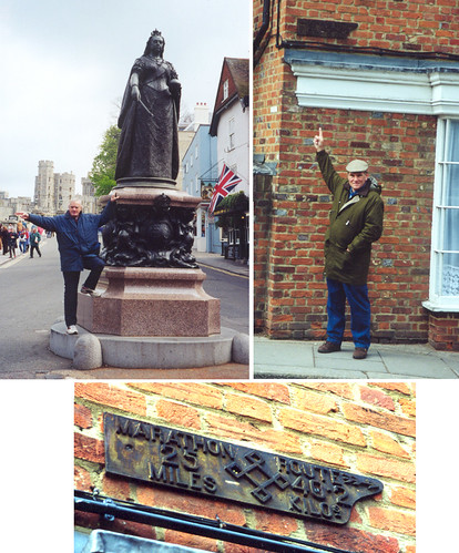
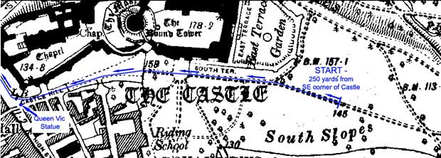
Start Windsor castle, East terrace, 700 yards from Queen Victoria's Statue.
Miles Kilometres
1 = 1.6 Barnespool-Bridge, Eton.
2 = 3.2 Windsor Road about 50 yards past the prince of Wales P.H.
3 = 4.8 Corner of High-street, Slough, and Uxbridge-road.
.... ..... ......
26* = 41.84 Entrance of Stadium, QQ. RR. SS.
26 miles 385yards = 42.263 kilometres. Full distance
* A rocket or gun will be fired at these three points.
The metrical distances are approximate.
The distance tablets have been arranged the reverse of the above, thus the 25th mile from the stadium is at Barnespool-Bridge, Eton.
TIME TABLE
.................
ENTRIES
.................
RULES OF THE RACE
1. The marathon Race of about 40 kilometres will be run on a course marked out on public roads by the Amateur Athletic Association and will finish on the running track of the stadium, where part of one lap will be run.
...........................
DESCRIPTION OF THE ROUTE
The race starts from Windsor Castle, near East Terrace (700 yards from Queen Victoria's Statue), .............


I have always been a bit curious about the stories of how the distance came to be settled. What seems clear from the above account published in the paper 2 days before the event, is that 
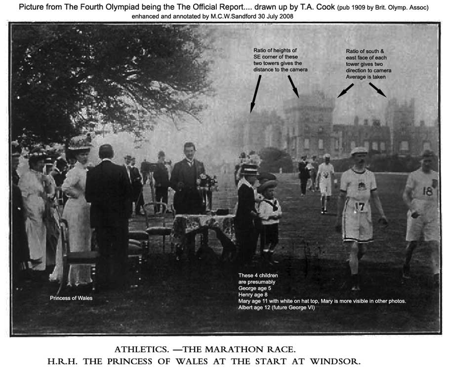
the 26 miles 385 yards was known beforehand, and there was certainly no last minute adjustment of the start so that members of the Royal Family, ill or not, could view it from their windows. Indeed, in The Times on 12 June 1908 it already says that the Marathon Race of "about 26 miles" was to be run from Windsor to the Stadium on Friday, July 24.

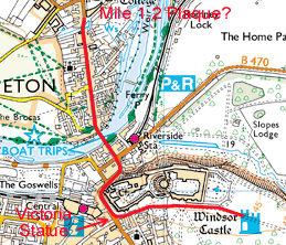
On 19 April 1998 I measured the distance from The Queen Victoria Statue in Windsor to Barnes Pool Bridge in Eton. It came to 1030 yards (with no SCPF since that was not in use then). The above account says the start was 700 yards from the Queen Victoria Statue, so that makes Barnes Pool Bridge to be 1730 yards from the start. This is 30 yards less than 1 mile. But there are several yards of uncertainty at the large statue (I used as a reference a drain lying on the SPR to one side of the statue) and the bridge was over 10 yards long, I used as a reference a plate saying AM Fowler CE. On a house immediately after crossing the bridge there is a plate saying 25 miles with an arrow pointing towards the finish. On investigating the history of the plate I found that it had been on this house belonging to Eton college and had been removed and put in a store room during repairs/decorations to the brickwork. It had been discovered in the storeroom and had been restored to its historic position. What I can confirm is that it must be very close to 1 mile from the start 700 yards from the Queen Victoria Statue.

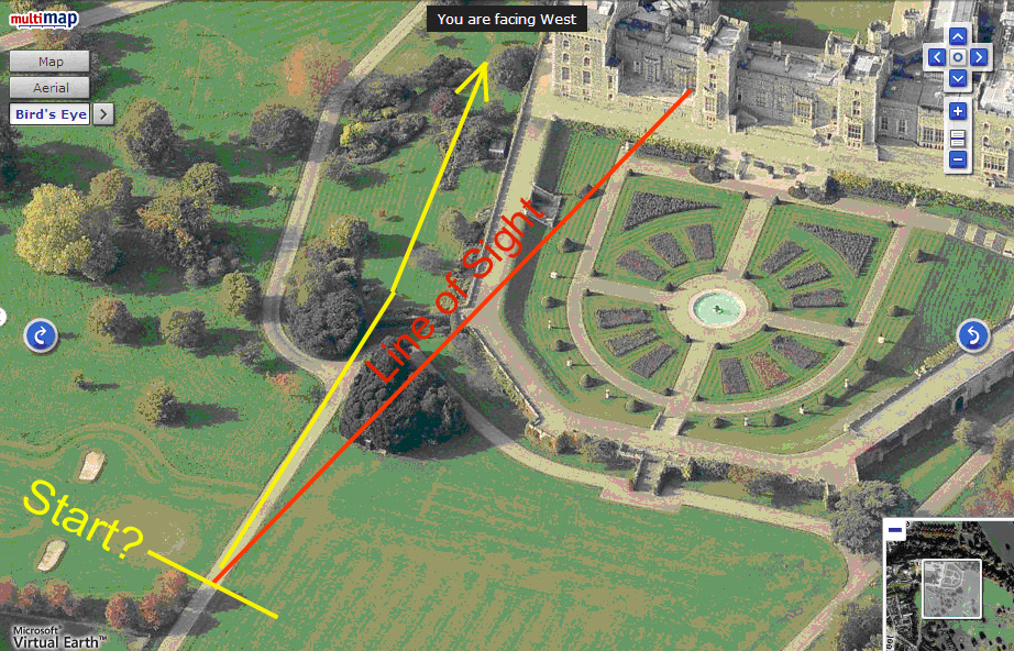
There is no public access to the first 600 yards of the course since these lie in private part of Windsor Castle. One can see the current layout quite well on the Google aerial view and measure a possible route along paths existing now. Those who know the area can identify the statue and confirm that the path below the centre of the east terrace is indeed close to 700 yards from the Queen Victoria statue.

I have seen it claimed that the race had been planned not to start in the private grounds of Windsor Castle but to start somewhere on the public part of the Long Walk which lies to the South of the Castle. The shortest distance from the Long Walk and a natural starting point with a superb view of the castle would be given by locating the start at the centre of the gates across the Long Walk which divide the public part from the private part to the North. If one measures from these gates across the Long Walk to the Queen Victoria Statue by the shortest public route one gets approximately 426 yards, so even with this as the starting point the race would not have been exactly 26 miles, but 26 miles 111 yards. So perhaps the marathon would have still been an odd distance even if it had only used public roads and had not been invited to use the castle grounds. Whatever, it is clear from the published distances and mile markers in advance of the race, that 26 miles 385 yards was well advertised before the race.
Here are some photos of the area in question. In 1998 John Disley took me to Windsor Castle and we looked at the start area of the 1908 marathon. John is seen at the Queen Victoria statue. Windsor Castle is in background. The runners would be coming from the castle toward the statue, and then turning right (left as viewed) to cross the Eton bridge. I am shown pointing at the 1.2 mile plaque which is still in place. The actual plaque is shown at bottom.

Last edited by peteriegel
I have now managed to locate the actual start line used for the 1908 race. It was indeed approximately 700 yards from the Queen Victoria Statue. It was not on the path that runs past the centre of the East Terrace, which I suggested as a possible location in my post above, but on another path that leads just South of East away from the SE corner of the Castle and about 250 yards from that corner. So it was about 150 yards distant from the East Terrace rather than close to it as implied by some books. This 150 yards is in fact the "missing 150 yards" once mentioned by John Disley when he was researching the marathon start.

I have drawn up a map based on an 1900 edition of the Ordnance Survey 1:10560 scale map. This shows the paths as they were in 1908. There have been alterations in the last 100 years as can be seen from a modern map or aerial view. Today there are two trees just south of the path near the 1908 start.
WHAT IF?

Mike Sandford has established a probable start line for the 1908 marathon course, 700 yards east of the Victoria Statue. This made me wonder where the plaque was located. When John Disley and I visited Eton we saw Windsor Castle and the area where the start probably was, as best we knew at the time. We also looked at the plaque which showed 25 miles to go. My problem is that I cannot recall where in Eton the plaque was located.

Using a modern Landranger map I did some map-scaling, using Mike’s start line as being 700 yards from the statue. Taking the route that seemed most likely, I located a point where the plaque seemed like it ought to be. See below.

I’m not sure whether the plaque is actually near the location I’ve plotted. A lot of road-changing can happen in a century.

Pete: Barnes-pool Bridge is where you have marked it just at the road bend with the blue water visible on either side of the road.

You can actually see the house carrying the 25 mile plate located on the North West end of the bridge parapet in the birds eye view at multimap N.B. for me this url only works in firefox. In internet explorer it just displays the ordinary area map and you would have to work through the menus to get the close up view of the bridge - not sure why my IE7 is not working like Firefox 3 does.

There is a slight correction to my post above. I believe John's start location (I imagine located opposite the statue of Dacko on the terrace) was reported to be said by him 155m short, not the 150y I quoted from memory.

My loose talk of yards and metres may fill some of today's measurers with horror, but please remember, that we are only trying to get roughly the right location. Presumably on the day when they put the white starting line down on the King's private road, they would have used measurements originating from The Queen Victoria Statue which was the established reference point. I doubt we shall ever be able to determine how accurate the whole process was, unless we can find an original measurement report. I am off to look in the archives next week to see if I can find anything.
Pete: I am glad it works. I use this site for reviewing details of courses which I have to certify, or in advance of measuring. Unfortunately not all places are covered yet by the birds eye view. One day measurers will be redundant if the course is not hidden under trees or by buildings!

As the link works here is another spectacular view showing the Castle The start as I have determined it is 50 to 100 yards off the bottom of the picture (Eastwards) along the road. You can easily see from this picture how the road has changed layout near the corner of the terrace. I have overlayed the modern map and the 1900 map and confirmed that the road locations are identical in the immediate vicinity of the start.

n.b you can drag the view up and down to follow the route. Also use the arrows to switch view direction.

Hopefully we can put to bed some of the fanciful interpretations one reads nowadays, copied from one author to another, about the start being under the nursery window of Windsor Castle.

The only children that were involved were the Princess of Wales's children, and four of them were with her watching the start from a few yards distance in a shade of a tree to the South of the start road. Her youngest child, Prince John, had only just had his 3rd birthday and I think wold have been too short to be one of the children in pictures of the Royal Party so he may well have been in a nursery, but perhaps back at Frogmore house where the Princess and Prince of Wales would have stayed( a short distance away within the Windsor Home Park)
quote:
....from 1902 to 1910 the future King George V and Queen Mary, with their children, frequently stayed there

Incidentally the Prince of Wales was away on a state visit to Quebec at the time. The Queen was presumably in London as she arrived at the stadium in time to see the finish. I dont know where the 66 year old King was. He had opened the games, and then the Times said quite specifically he would play no more part in the proceedings and that the Queen would dole out the medals on the final day following the marathon.
This view looking north is even better. The start line is roughly at the right edge of the picture if your browser is filling a 1600 pixel wide screen as mine is. Otherwise you have to pan.

You can also see how high the terrace was. I would never start a marathon actually on the terrace and expect 55 runners to descend the steps at the end to cross the path junction near the castle entrance visible in the middle of the South Walls.
Pete: Amusing photos

Mark: A nice challenge! But it is too challenging to measure really accurately. I would like to find Andrew's measurement report but I hold little hope.

Anyway here is one of the photos which I have been using to determine the start position. I have enhanced it in
photoshop so you can see the towers of Windsor Castle more clearly. I have measured these in the Photoshop to derive the distance and direction of the camera from the castle.

I used simple perspective to determine the camera position. This obviously ignores possible camera distortions, so it is not exactly high tech. Also I only did the measurements rather approximately. I also measured the castle relative dimensions using a vertical aerial shot. I found a long distant photo which enabled me to see that the towers on the South were virtually the same height.

It was all somewhat rough but the camera position comes out a little before the 700 yard East of Queen Vic statue point along the road. Perhaps some one would like to have a more careful try.

In this picture the runners seem to be heading towards what might have been an assembly area behind the camera, just to the south of the start position. The only thing I cant see in the picture is the road which should be leading towards the Castle nearly parallel to and to the right of the line the walkers are taking. It may be that the road is slightly lower than the grass and does not show up in an oblique view, or perhaps it is just the same brightness as the grass.


As an up to date footnote: I have just seen my son's Iphone displaying birds eye pictures of the route as we drove home this evening. When we got home the blue dot was across the stream 40 m away, but then as he started to get out of the car the blue dot jumped back exactly into our drive - most impressive, especially as you can see our cars in the picture. It almost made us feel we could look up and see the camera monitoring our movements. Perhaps consumer GPS will one day be useful for course measurement, when in the open.
Mike – I tried figuring it out using graphics, as the trigonometry was starting to drive me crazy. I used only the angles determined by using the ratios of the apparent face width on the two towers. The average of my crude figurings put the start closer to the terrace than the point which is 700 yards from the Victoria statue.

Also, without getting too scientific about it, just looking at the picture of the Royal Family at the start puts one well out on the lawn, near the point you originally established. Well southeast of the terrace. It does not confirm my work. I believe the picture, and I think that the “700 yards” is the best reference we are likely to get.

Of course, we don’t know where the start actually was relative to the Royal Family. I doubt they’d be enjoying brunch immediately adjacent to the starting line. It looks like they were in a nice shady spot, maybe or maybe not right at the start, but picked for comfort and ambience.
Thanks for trying Pete. I will work through it again carefully and document my steps. My previous rather rushed work does need to be properly checked.

Just looking at the picture, I think can see a more accurate way of getting the direction of the camera, using the SE edges of the three towers.

I agree about the choice of spot for the Royal family. Note the servants must have struggled out on the hot day with the chairs and the table. Strangely I cant see any drinks on the table.
Here’s a pretty good estimate of the start line. In the Royal Family photo there is a decent line of sight which lines up the south edge of the second tower with the corner break on the terrace. If the path is the same as in 1908 it should do the job. Happily it agrees with Mike’s first estimate.


Of course, it assumes that the start line is on the camera's line of sight, which it probably is not. Still, it puts us in the neighborhood.
Last edited by peteriegel
Yesterday I visited the Archive of Westminster University in London. This is a new university founded in 1992 from what in 1908 was the The Polytechnic Young Men's Christian Institute. I examined in the archives papers and pictures relating to the Polytechnic Harriers and also the Polytechnique Magazine which was a monthly Journal of the Institute and contained each month reports from the sporting clubs of the Institute including The Polytechnic Harriers. These monthly reports were often from Jack M Andrew who was the secretary of the Harriers. Jack Andrew is of interest to us as course measurers since he was responsible for the course of the 1908 Olympic Marathon, and thus his decisions led to the 1908 Olympic Marathon being 26m 385 yards and thus to the distance which was subsequently standardised on.

I am going to prepare a web page with details of what I found, but I can quickly say that it is very clear that the Jack Andrew had measured the route before the trial race on 25 April 1908. Whereas the trial race started on the Long Walk south of the Windsor Castle (at a point 700 yards from the Queen Victoria Statue) in the programme for the trial race it says on the Olympic Marathon, "It is hoped that the King will graciously consent to the start being made from the terrace of Windsor Castle, in which event the distance will be about 26 miles to the edge of the stadium track. These measurements have been taken by Mr J.M.Andrew, Hon. Sec. of the Polytechnic Harriers who has been largely responsible for the course so happily selected."

The map produced in April 1908 shows the Olympic start on the East Lawns beyond the East Terrace as we have already confirmed above from study of the photographs. So we can safely say that Jack Andrew decided on 26 miles to the stadium track edge. The story of the distance being set my the demand of Royalty to have the start viewable from nursery windows is not compatible with the account in the Harriers archives.

That is how 26 miles comes about. In the April trial programme it says that for the Olympic Marathon there would be one complete lap of the stadium track which was one third of a mile and this is shown as: Full Distance 26 & one third Miles, 42.3795 Km. It was a change of the stadium entrance at the finish that resulted in the 26 miles 385y. The race still finished on the main stadium finish line below the royal box, as all the track races did. So it was not the Queen demanding that the race finish in front of her that gave the extra 385 yards, but the desire of the organisers to let the finishing runners pass by most of the stadium spectators before reaching the standard finishing line.

One interesting snippet from the Harriers accounts for 1908 is the item associated with the trial race: Sundry Expenses, fares etc Measuring Course £2:15s. So that was the measurer charged for his work, which was met by his club. Bearing in mind the 100 fold inflation over the last 100 years this would not be out of line for what I would charge for expenses for several day's work on a marathon today (my time of course still being free of charge to Athletic Clubs just as it was in those days of Amateur Sport.)

Preparing and Printing the map of the route, making fixing and removing direction and mile post tablets (which where cast in metal - see the one pictured above still at BarnesPool Bridge) shows up in the trial race costs as £55:5s:2d. However, this sum was refunded to the Polytechnic Harriers by the British Olympic Committee. Presumably the expenses for refixing them for the Olympic marathon were met directly by the BOC.
The oft-repeated story of the 1908 Olympic Marathon in London invariably includes a reference to a last-minute change in the course, moving the start so that the Royal children could observe it from the Windsor Castle terrace.

We’ve seen Mike Sandford’s work here which tends to debunk the idea that the start was placed at the last minute.

In the latest issue of Distance Running, the AIMS/IAAF road running magazine, Hugh Jones has written an article about the 1908 race. It includes some background on the layout of the course. It’s well worth reading. See it at Jones Article.

Add Reply

Post
×
×
×
×
Link copied to your clipboard.
×