THESE ARE THE CALIBRATION COURSES I USED
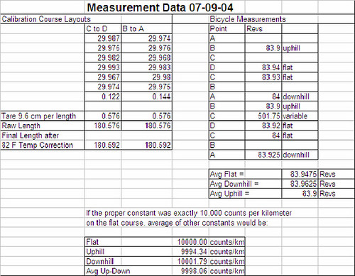
HERE IS MY MEASUREMENT DATA
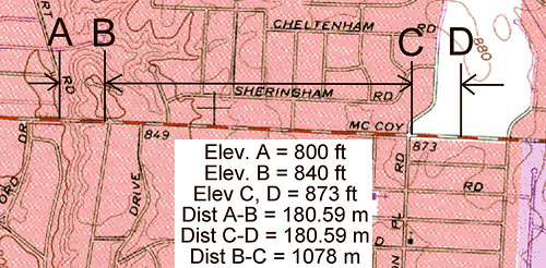
I did a similar experiment to Mark’s today. I laid out two short calibration courses on McCoy Road, in northwest Columbus, striving to make them identical in length. I used the solo method, installing nails at each point and taping between them. Because my zero point is offset from the loop, I added 9.6 cm to each measured length. All taping was done in full sun, which did not vary during the exercise. Temperature was 81 to 84 F in the shade. One course was flat. The other was very hilly, having an elevation change of 40 feet over 180.59 meters, which is a titanic 67.5 m/km. It’s quite steep. The two calibration courses were separated by 1.08 km. The asphalt pavement was the same composition and age all along the route.
I rode from end to end twice in each direction, beginning at the west end. I used a Protégé cyclocomputer and counted wheel revolutions.
My front tire was pumped to 100 psi before the work began, and the rear to 80.
There appeared to be little wind present.
My data showed that there was very little error associated with using the average of uphill and downhill rides, even on such a ridiculously steep calibration course, amounting to only 0.2 m/km, well within our SCPF of 1 m/km.
I expect that further experiments, should they be done, will find results close to these. I believe the greater differences obtained by Mark to be caused by the two different pavement compositions.