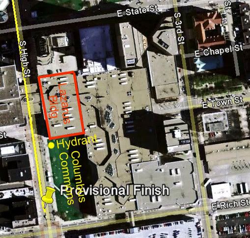
I laid out a preliminary 5k course on Saturday morning. I used a fire hydrant as a reference for the finish line. The hydrant was at the extreme northwest corner of Columbus Commons. The Commons is a new park in downtown Columbus, replacing several old buildings that were torn down and replaced with grass.
When I was done the course was a bit short, and I found that I needed to add 600 feet. Using a measuring wheel I measured south from the hydrant and established a provisional finish line. I measured twice, obtaining 600 and 601 feet, thus had confidence in my measurement.
Later I used Google Earth to check out the 600 feet. To my surprise the Google distance came out to just a bit over 300 feet. This was vexing, and I fiddled with various comparisons to see if I could figure out where the error was. I was greatly concerned because I have become a believer in the accuracy of Google Earth.
After several frustrating and ineffective tries to find the error I was stumped. Then I did a search for “Columbus Commons” and obtained a map of the site. I discovered that the Lazarus building was no longer there. It had been torn down and the area replaced by grass. Thus my reference was at the wrong place – it was actually at the northwest corner of the Lazarus Building in the Google image. Sure enough, the date of the Google image was 2/28/2007. It was photographed before the Lazarus building was torn down.
Using the northwest corner of the former Lazarus Building as my reference, I now got close to 600 feet. This was an instructive lesson. The Google Earth image we see is not actually up to date.